MENU

Sections

  • Home
  • About
    • The Chestertown Spy
    • Contact Us
    • Advertising & Underwriting
      • Advertising Terms & Conditions
    • Editors & Writers
    • Dedication & Acknowledgements
    • Code of Ethics
    • Chestertown Spy Terms of Service
    • Technical FAQ
    • Privacy
  • The Arts and Design
  • Local Life and Culture
  • Public Affairs
    • Ecosystem
    • Education
    • Health
  • Community Opinion
  • Donate to the Chestertown Spy
  • Free Subscription
  • Talbot Spy
  • Cambridge Spy

More

  • Support the Spy
  • About Spy Community Media
  • Advertising with the Spy
  • Subscribe
May 23, 2025

Chestertown Spy

Nonpartisan and Education-based News for Chestertown

  • Home
  • About
    • The Chestertown Spy
    • Contact Us
    • Advertising & Underwriting
      • Advertising Terms & Conditions
    • Editors & Writers
    • Dedication & Acknowledgements
    • Code of Ethics
    • Chestertown Spy Terms of Service
    • Technical FAQ
    • Privacy
  • The Arts and Design
  • Local Life and Culture
  • Public Affairs
    • Ecosystem
    • Education
    • Health
  • Community Opinion
  • Donate to the Chestertown Spy
  • Free Subscription
  • Talbot Spy
  • Cambridge Spy
Archives Ecosystem Eco Notes

Maryland Mesonet Weather Monitoring Station

August 28, 2024 by Spy Desk Leave a Comment

Share

Screenshot

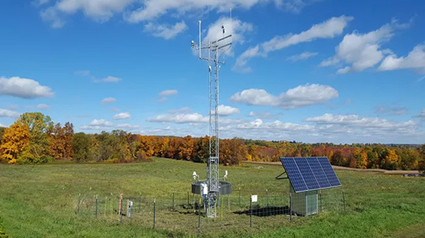
The Kent County Office of Emergency Services (OES) is proud to announce its partnership with the University of Maryland, the Maryland Department of Emergency Management, the Maryland Environmental Service, and the Maryland Department of Health in utilizing the newly activated Maryland Mesonet weather monitoring station. This station is located on the grounds of the Behavioral Health Whitsitt Center in Chestertown, Kent County, MD, and provides real-time, live weather data. To view the station’s live data, visit:   https://mesonet.umd.edu.

The Chestertown station is one of over 70 planned stations across the State of Maryland. Kent County OES will use information and data from the station to forecast weather events allowing probable advance notification of adverse weather conditions. The stations will be spaced 10 miles apart and are equipped to sample and transmit collected data within one minute.   Variables to be measured include wind speed and direction, solar radiation, air temperature, relative humidity, atmospheric pressure, rainfall, snow depth, and soil moisture and temperature in the upper 1 m soil layer.

These stations will support local decision-making, quantify impacts on critical infrastructure from natural hazards, enhance public safety planning and identify long-term community risk and the data can be leveraged when requesting Presidential Disaster Declarations and Hazard Mitigation funding.

Other data-driven applications include Agriculture, Education, Utilities, Green Energy, Environment, Forest/Wildfire Management, Transportation and Tourism.

The Spy Newspapers may periodically employ the assistance of artificial intelligence (AI) to enhance the clarity and accuracy of our content.

Filed Under: Archives, Eco Notes

Letter to the Editor: An Open Letter in Reply to Brian Speer of Washington College New Season for the Allegro Children’s Chorus

Write a Letter to the Editor on this Article

We encourage readers to offer their point of view on this article by submitting the following form. Editing is sometimes necessary and is done at the discretion of the editorial staff.

Leave a Reply Cancel reply

Your email address will not be published. Required fields are marked *

  • About
  • Subscribe
  • Contact Us
  • Advertising & Underwriting

Copyright © 2025

Affiliated News

  • The Cambridge Spy
  • The Talbot Spy

Sections

  • Arts
  • Culture
  • Ecosystem
  • Education
  • Health
  • Local Life and Culture
  • Spy Senior Nation

Spy Community Media

  • About
  • Subscribe
  • Contact Us
  • Advertising & Underwriting

Copyright © 2025 · Spy Community Media Child Theme on Genesis Framework · WordPress · Log in