

Climate scientists expect a particularly strong El Nino this summer to lead to fewer hurricanes in the Atlantic.
The probability that at least one major hurricane will make landfall along the East Coast in 2014 is 20 percent, down from the average of 31 percent over the last century, according to a Colorado State University report released April 10.
The report’s authors, Philip Klotzbach and William Gray, wrote that there should be below-average hurricane activity because of the “significant impact” El Ninos have on Atlantic hurricane activity.
The probability of a major hurricane — with winds above 110 miles per hour — is estimated to be about 65 percent of the long-term average because of the emergence of the climate phenomenon.
It’s unclear how El Ninos form, but abnormally warm water under the surface of the Pacific Ocean is a reliable indication that an El Nino is coming, according to a Nature Climate Change paper by climate scientists Raghu Murtugudde and Nandini Ramesh published in January 2013.
El Ninos have varied effects based on how they move jet streams, fast-moving air currents that stretch around the globe.
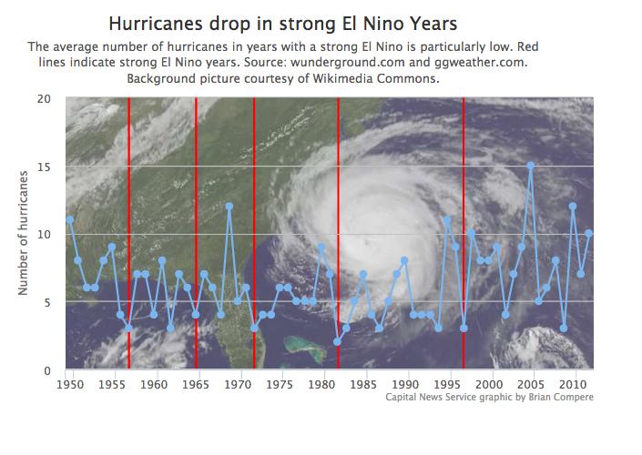
A CNS analysis of wunderground.com and ggweather.com data found that on average, there were four fewer hurricanes in years classified as having had a strong El Nino than years without an El Nino.
For 2014, the CSU report predicted nine tropical storms (the long-term median is 12), three of which will become hurricanes (the median is 6.5), including one major hurricane (the median is 2).
Despite the optimistic forecast, Ed McDonough, public information officer for the Maryland Emergency Management Agency, said he still worries that a hurricane could make its way up the coast to Maryland.
“It really doesn’t matter how many hurricanes we have in a season. If we have one hurricane, it’s a bad season,” he said. “I don’t worry so much about the forecast; it doesn’t really change how we prepare.”
Residential properties in Maryland have the 11th-highest potential for exposure to hurricane storm surge damage, according to 2013 data from CoreLogic, a business data and analytics firm.
Hurricane Isabel in 2003 brought record-high tides to Maryland, breaking a 1933 record with a tide 7.58 feet above normal. Hurricanes Frances, Ivan, Jeanne and Irene, as well as Superstorm Sandy, have also brought flooding, heavy rain and wind, and widespread power outages in the past decade.
Moderate to strong El Ninos occur about once every 3 to 7 years on average, according to the CSU report. Murtugudde said that because strong El Ninos tend to occur about every 15 years, “we’re due for a big one and this could be it.”
It will be important to monitor El Nino conditions as they develop this summer, Murtugudde said. But for now, it’s unlikely that an El Nino would have significant damaging effects in Maryland.
Usually, El Nino-influenced movements of the jet streams lead to increased rainfall in the Southwest and Southeast and increased snow in the Northeast, Murtugudde said.
If the El Nino gets too strong, however, it could contribute to severe winter weather and more sleet in Maryland, Murtugudde said. Although the jet stream shifts usually don’t affect mid-Atlantic states badly, it’s too early to tell what effects these shifts could have on the region.
The increased rainfall El Ninos can bring can be helpful in minimizing droughts and wildfires in California, Murtugudde said. But particularly strong El Ninos can still have damaging effects, including floods. The most recent “big” El Nino was in 1997-98, Murtugudde said, and it led to “huge” storms across California that caused mudslides.
By Brian Compere
Capital News Service
Write a Letter to the Editor on this Article
We encourage readers to offer their point of view on this article by submitting the following form. Editing is sometimes necessary and is done at the discretion of the editorial staff.