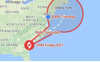


Tropical Storm Hermine could bring significant rainfall and wind to portions of Maryland beginning Saturday morning, making for a potentially hazardous Labor Day weekend. The Storm, which is currently located over Florida, is moving north-northeast and is forecast to be located off the Eastern Shore of Maryland by Saturday. Rain, wind and localized flooding may continue throughout the weekend and into early next week.
The National Weather Service (NWS) has issued tropical storm warnings for St. Mary’s, Dorchester, Somerset, Wicomico and Worcester Counties. In addition to tropical storm force rain and wind, these areas could experience tidal and coastal flooding.
“Marylanders need to monitor trusted weather sources, such as the NWS weather forecast offices and local news stations, in order to stay updated on this tropical system and associated rain,” said Russ Strickland, executive director of MEMA. “Residents and visitors to the Eastern Shore should pay extra attention—tropical storm tracks can change quickly and unexpectedly.”
Those in potentially affected areas should be familiar with evacuation routes, have a communications plan, keep a battery-powered radio handy and have a plan for pets.
Find out more information about hurricane and storm preparedness on our website mema.maryland.gov or follow our Twitter feed @MDMEMA, Facebook page and Instagram account, or by viewing our hurricane preparedness whiteboard video.
Write a Letter to the Editor on this Article
We encourage readers to offer their point of view on this article by submitting the following form. Editing is sometimes necessary and is done at the discretion of the editorial staff.