MENU

Sections

  • Home
  • About
    • The Chestertown Spy
    • Contact Us
    • Advertising & Underwriting
      • Advertising Terms & Conditions
    • Editors & Writers
    • Dedication & Acknowledgements
    • Code of Ethics
    • Chestertown Spy Terms of Service
    • Technical FAQ
    • Privacy
  • The Arts and Design
  • Local Life and Culture
  • Public Affairs
    • Ecosystem
    • Education
    • Health
  • Community Opinion
  • Donate to the Chestertown Spy
  • Free Subscription
  • Talbot Spy
  • Cambridge Spy

More

  • Support the Spy
  • About Spy Community Media
  • Advertising with the Spy
  • Subscribe
December 4, 2023

Chestertown Spy

Nonpartisan and Education-based News for Chestertown

  • Home
  • About
    • The Chestertown Spy
    • Contact Us
    • Advertising & Underwriting
      • Advertising Terms & Conditions
    • Editors & Writers
    • Dedication & Acknowledgements
    • Code of Ethics
    • Chestertown Spy Terms of Service
    • Technical FAQ
    • Privacy
  • The Arts and Design
  • Local Life and Culture
  • Public Affairs
    • Ecosystem
    • Education
    • Health
  • Community Opinion
  • Donate to the Chestertown Spy
  • Free Subscription
  • Talbot Spy
  • Cambridge Spy
News Maryland News

Legislative Redistricting Advisory Commission Releases Four ‘Concept’ Congressional Maps for Public Comment

November 11, 2021 by Maryland Matters

Share

The Legislative Redistricting Advisory Commission released four draft concept congressional maps Tuesday evening.

The redistricting panel, convened by Senate President Bill Ferguson (D-Baltimore City) and House Speaker Adrienne A. Jones (D-Baltimore County) is tasked with drawing up congressional and legislative maps for the General Assembly to consider. Lawmakers are set to return to Annapolis on Dec. 6 for a special session to handle congressional redistricting.

The four conceptual congressional maps are available online alongside information about the population and racial makeup of each district — but not the partisan political breakdown. Some of the configurations are vast departures from current maps, including two draft maps of a 1st District that crosses the Chesapeake Bay Bridge to include portions of Anne Arundel County alongside the Eastern Shore.

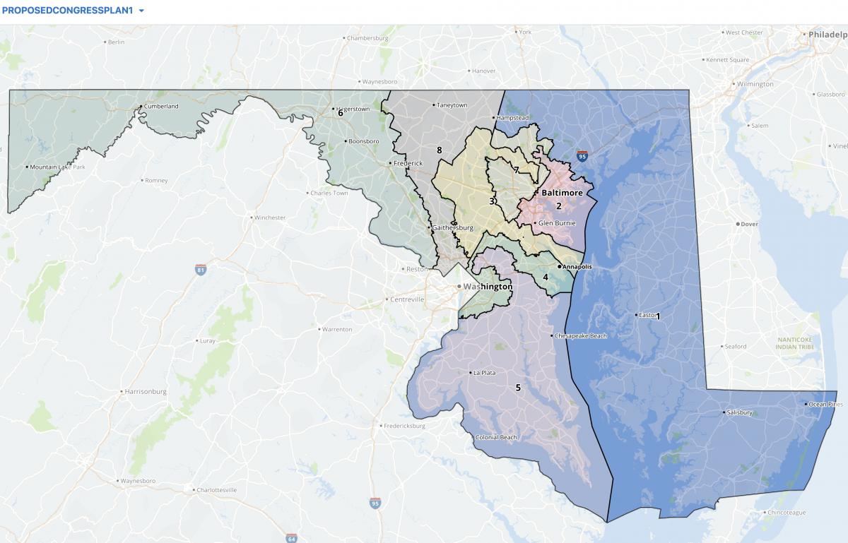
LRAC congressional plan 1

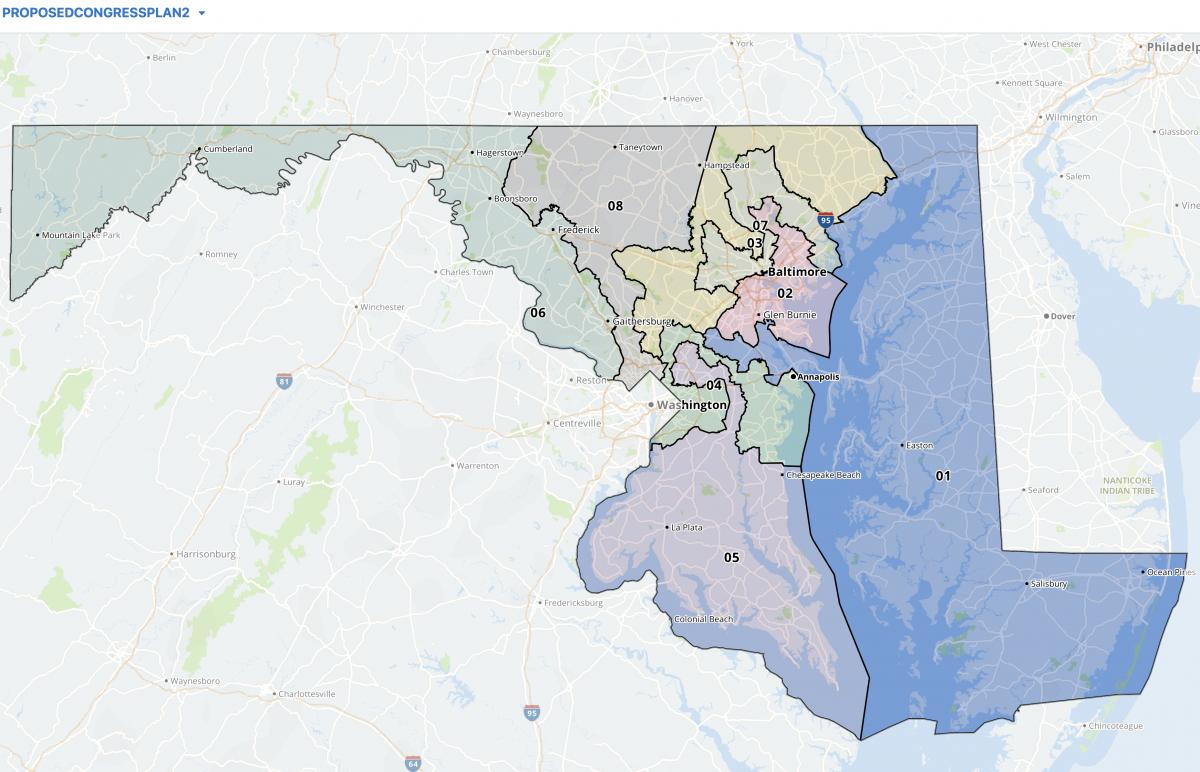
LRAC congressional plan 2

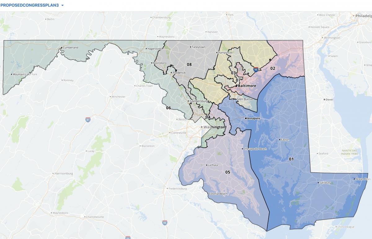
LRAC congressional plan 3

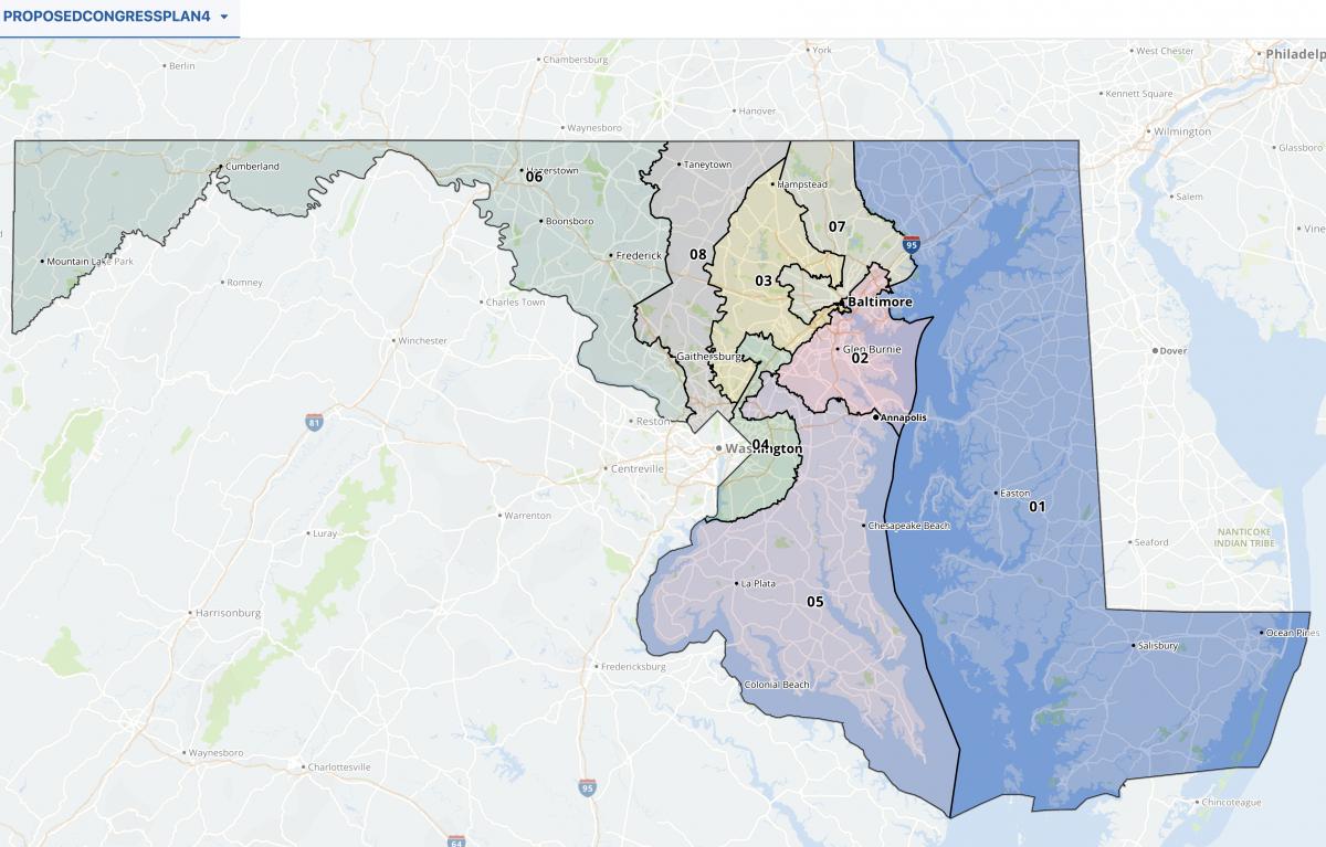
LRAC congressional plan 4


Commission Chair Karl Aro, a former head of the nonpartisan Department of Legislative Services, said in a statement that the conceptual maps are a baseline for public comment and based on testimony the commission has received in their public hearings so far.

“The approach that this commission has taken is to create a set of four Congressional map concepts for public comment,” Aro said. “It is our belief that Marylanders should see and comment on more than just a single map. Each of these four concepts represent a starting point for an approach that was grounded in testimony the commission heard.”

Aro added that, “to the extent practicable,” the maps aim to keep Marylanders in their current congressional districts.

“Portions of these districts have remained intact for at least 30 years and reflect a commitment to following the Voting Rights Act, protecting existing communities of interest, and utilizing existing natural and political boundaries,” Aro said. “It is our sincere intention to dramatically improve upon our current map while keeping many of the bonds that have been forged over 30 years or more of shared representation and coordination.”

Dave Wasserman, the House analyst for the nonpartisan Cook Political Report tweeted Tuesday that the four congressional maps include “two that would essentially leave Rep. Andy Harris (R) safe and two weak gerrymanders that could still give him a path to reelection.”

Wasserman wrote that the third map proposal would flip Harris’ 1st District from “Trump +20 to Biden +10 — about as blue as Virginia.”

“That’s pretty surprising, considering MD Dems could easily make it Biden +15 or more and have shown little restraint gerrymandering the state in the past,” Wasserman wrote.

The General Assembly, where Democrats hold a veto-proof majority in both the House of Delegates and the state Senate, will have the final say over redistricting in Maryland.

Marylanders who testified at the Legislative Redistricting Advisory Commission’s previous public meetings have urged the commission to release draft maps to the public, arguing that the public should have a chance to weigh in before the proposal heads to the General Assembly.

“It seems rather difficult for people to comment on the basis of a blank map,” Jacqueline Coolidge of the League of Women Voters told the panel at an online hearing in early October.

Ferguson and Jones issued a joint statement on Twitter after the release of the maps and said they were pleased the maps were released now, “providing the public with several weeks for input and reaction.”

“Continuing our open and transparent process, we encourage all Marylanders to provide testimony and feedback on these concepts during our upcoming statewide virtual hearing this Monday at 6 p.m. and through the LRAC email address in the coming weeks.”

Gov. Lawrence J. Hogan Jr. (R) created a separate panel, the Maryland Citizens Redistricting Commission, to draw up congressional and legislative maps that he will propose to the General Assembly. That commission, which included three Republicans, three Democrats and three unaffiliated voters, finalized its redistricting proposal earlier this month.The congressional and legislative maps proposed by the Maryland Citizens Redistricting Commission are available online.

Hogan can veto congressional maps, and previously said he would oppose maps from the General Assembly that “don’t follow what the Citizens Redistricting Commission has come up with.” While Hogan could veto the congressional maps, Democrats easily overrode his vetoes on several measures during the 2021 legislative session.

Commission members will hold a statewide virtual public hearing at 6 p.m. Monday, Nov. 15. Email testimony may be sent to [email protected].

By Bennett Leckrone and Danielle E. Gaines

The Spy Newspapers may periodically employ the assistance of artificial intelligence (AI) to enhance the clarity and accuracy of our content.

Filed Under: Maryland News Tagged With: Congress, congressional, districts, gerrymander, map, maps, Maryland, redistricting

Politico: Md. Dems Eyeing State’s Only Republican Congressman in Redistricting

November 9, 2021 by Spy Desk

Share

Democratic leaders in Maryland are considering a congressional redistricting that could result in eight Democrats representing the state in Congress, Politico reported Nov. 9.

The state’s current congressional delegation has seven Democrats and one Republican, First District Rep. Andy Harris. Prior to the 2010 redistricting, there were two Republicans representing Maryland, one in western Maryland and one in the First District, which includes the Eastern Shore.

The Maryland General Assembly, with solid Democratic majorities, will have the final say on the districts for Congress, Maryland Senate, and Maryland House of Delegates.

The legislature’s redistricting advisory commission has additional public hearings scheduled through mid-November, but is expected to release a draft congressional map this week, according to Politico.

A citizens redistricting commission appointed by Gov. Larry Hogan has completed its work and proposed a congressional map with six Democratic districts and two Republican districts.

The General Assembly will begin meeting Dec. 6 in a special session to map the congressional districts.

The Spy Newspapers may periodically employ the assistance of artificial intelligence (AI) to enhance the clarity and accuracy of our content.

Filed Under: News Homepage Tagged With: andy harris, Congress, house of delegates, Maryland, redistricting, senate

Md. Citizens Redistricting Commission Finalizes Congressional, Legislative Maps

November 4, 2021 by Maryland Matters

Share

The Maryland Citizens Redistricting Commission, created by Gov. Lawrence J. Hogan Jr. (R) to draw up maps that he will propose to the General Assembly, finalized its redistricting proposals at a Wednesday evening meeting.

Commission members voted 8-1 to approve of congressional maps and unanimously to approve legislative maps at the meeting. Those maps, which are available online, are vastly different from the state’s current configuration because commissioners started from scratch and didn’t use existing districts to begin with.

Commission members weren’t allowed to consider partisan district makeup when creating the maps, but their congressional maps received high marks for partisan fairness from the Princeton Gerrymandering Project. The congressional map creates six Democratic and two Republican districts as opposed to the current 7-1 configuration, according to the Princeton Gerrymandering Project’s Redistricting Report Card. That report also rated the commission’s state senate maps highly in October, although panelists have since made changes to the legislative map and the group hasn’t reviewed the finalized version yet.

The commission is composed of three Republicans, three Democrats and three unaffiliated voters, and has been conducting public hearings on redistricting since June. Hogan has said he will submit the commission’s maps to the General Assembly, where Democrats hold a veto-proof majority in both the House of Delegates and the Senate. Lawmakers have formed their own redistricting panel, the Legislative Redistricting Advisory Commission, to conduct public hearings and draw up congressional and legislative maps.

Here are a few takeaways from the Maryland Citizens Redistricting Commission’s final redistricting proposal:


County splits are minimized compared with current congressional maps

Keeping communities and neighborhoods intact was a common ask from residents throughout the commission’s public hearings, and commissioners said Wednesday evening that they tried to minimize county splits as much as possible in their proposed maps.

Under the state’s current congressional maps, Baltimore City is split between the 2nd, 3rd and 7th Districts. The city would be contained within a single congressional district alongside portions of northern Anne Arundel County in the commission’s proposed maps.

Commission member William Thomas (D), a Baltimore City resident, was the only commission member to vote against the congressional proposal. Thomas said he was “disappointed” that he received little feedback on the congressional maps from city residents, and added that he couldn’t be sure the map accurately reflected what Baltimore residents want in their congressional configuration. He said he would’ve preferred an east-west split for Baltimore in the commission’s maps.

Anne Arundel County, currently split between four congressional districts, would also be kept more intact: Aside from neighborhoods included in a district with Baltimore City, the county is contained within a single district with all of Howard County and a small portion of northern Calvert County in the proposed maps.

Baltimore County, which is also split between four congressional districts in current maps, would be split between two districts from north to south. The northern portions of the county are included with the Eastern Shore in the 1st District, and the southern half of the county has its own self-contained district.

Northern portions of Montgomery County are kept in a district with Western Maryland, although that district would include all of Frederick and Carroll counties. Most of Montgomery County would include a self-contained district extending from Germantown to east of Aspen Hill. The eastern portion of the county, including Silver Spring and White Oak, would be included in a district with northern Prince George’s county.

Roughly the southern half of Prince George’s County is included in a district with Charles, St. Mary’s and Calvert counties.

The legislative map includes both single- and multi-member delegate districts

In his executive order creating the commission earlier this year, Hogan said single-member delegate districts should be used in the map “to the extent possible.” After weeks of debate, panelists decided to use a mix of single- and multi-member districts based on population density.

Eighteen of 47 state Senate districts contain three-member delegate districts in the Maryland Citizens Redistricting Commission’s proposed maps.

The commission’s proposed delegate map generally includes multi-member House districts in counties with a population density of more than 2,000 per square mile, commission Co-Chair Walter Olson (R) previously said.

There are various exceptions to the use of multi-member districts in the commission’s map: Single-member districts are used as required by the federal Voting Rights Act to ensure representation of people of color, and a Senate district of fewer than 500 people per square mile that is in a county with a population density of more than 2,000 per square mile will have single-member House districts. That exclusion would affect the Agricultural Reserve in northern Montgomery County, which would include single-member districts.

Single-member House districts are also used in all districts that cross county lines except District 39, which crosses from Prince George’s County into Charles County, because the population on the Charles County side of the district is too low to “make up the core of a single-member district,” according to a previous email from Maryland Department of Planning Public Affairs Director Kristin R. Fleckenstein.

The Maryland constitution allows state delegate districts with between one and three members, and the state currently uses a mix of both single- and multi-member districts. Delegate districts must be nested within state Senate districts in Maryland, with three delegates per Senate district. Potential configurations include three single-member delegate districts within a Senate district; one single-member delegate district and a two-member delegate district; and one three-delegate district.

Multi-member districts are more widely used than single-member districts statewide in current legislative maps. Single-member districts are generally used in more rural or geographically large districts or when required by the Voting Rights Act. They are also sometimes used in current maps when a portion of a Senate district crosses county lines.

Proponents of single-member districts who testified during the Maryland Citizens Redistricting Commission’s three rounds of public hearings said they make it easier for political newcomers to challenge incumbents and create more specialized local representation, while proponents of multi-member districts have said they offer voters broader representation and helped the Maryland General Assembly outpace other states in terms of gender and racial diversity.

The MCRC maps are highly unlikely to be enacted

The General Assembly, where Democrats hold a veto-proof majority in both the House of Delegates and the Senate, will have the final say over redistricting in Maryland. Legislative leaders created their own commission, the bipartisan Legislative Redistricting Advisory Commission, to draw up their own set of congressional and legislative maps.

The legislative commission includes four Democratic and two Republican legislative leaders and is chaired by Karl Aro, the former director of the nonpartisan Department of Legislative Services. That panel kicked off its public hearings in September, but hasn’t produced congressional or legislative maps for public comment yet.

Hogan said last week that he would oppose maps from the General Assembly that “don’t follow what the Citizens Redistricting Commission has come up with.” The governor can veto congressional maps, but Democrats hold a veto-proof majority in both the House of Delegates and Senate and easily overrode his vetoes on several measures during the 2021 legislative session.

Lawmakers are planning a special session in December to tackle congressional redistricting. The Legislative Redistricting Advisory Commission is set to wrap up its hearings this month before recommending maps to the General Assembly.

By Bennett Leckrone

The Spy Newspapers may periodically employ the assistance of artificial intelligence (AI) to enhance the clarity and accuracy of our content.

Filed Under: Maryland News Tagged With: commission, congressional, districts, legislative, Maryland, redistricting

Shore Residents Say Legislative Redistricting Panel Should Boost Representation of People of Color

October 19, 2021 by Maryland Matters

Share

Eastern Shore residents urged members of the Legislative Redistricting Advisory Commission to boost representation for people of color in their legislative maps at a Monday evening public hearing.

Sonya Whited, a Wicomico County resident, said during a public hearing at the Todd Performing Arts Center in Wye Mills that the commission should look at drawing an additional single-member delegate district with a majority of people of color on the Eastern Shore in their proposed legislative maps in addition to District 37A, which is represented by House of Delegates Speaker Pro Tem Sheree Sample-Hughes (D).

“We are at the point where carving out one minority district represented by Delegate Sheree Sample-Hughes is not enough to truly address the concerns of other minority and sometimes marginalized communities,” Whited said. “I am hopeful that this critical district could be part of the fair map drawing process versus a court case.”

Patrick Firth, the chairman of the Talbot County Democratic Central Committee, said the panel could create an additional single-member district that would stretch from Salisbury University to the University of Maryland Eastern Shore, the historically Black university in Princess Anne.

“It’s time for the General Assembly to recognize the changing population and growing diversity (of) the Eastern Shore,” Firth said.

He also said Talbot County should be drawn into a single-member district with parts of Caroline Counties rather than a broader district with portions of the lower Eastern Shore.

Whited also said she wants the commission to largely keep multi-member delegate districts in their legislative maps. Maryland’s delegate maps currently contain a mix of single- and multi-member districts, with multi-member districts generally used in more densely populated areas and some rural areas including on the Eastern Shore. Whited and other proponents of multi-member districts say having multiple delegates gives voters access to legislators with different areas of expertise and broader representation.

Single-member districts are generally used in geographically larger and more rural districts or when required by the Voting Rights Act to ensure representation of people of color. They are also sometimes used when a portion of a senatorial district crosses county lines. Proponents of single-member delegate districts say they make it easier for political newcomers to challenge incumbents and also give voters a single point of contact in the House of Delegates.

Diana Waterman, a Queen Anne’s County resident and former state Republican Party chair, testified in favor of single-member districts at the public hearing, and argued that using single-member districts statewide “would ensure that all citizens receive the same level of service from their delegate.”

Waterman said the LRAC should consider supporting maps drawn up by the Maryland Citizens Redistricting Commission, a multi-partisan panel created by Gov. Lawrence J. Hogan Jr. (R) and tasked with drawing up congressional and legislative maps that he will propose to the General Assembly. That panel recently released draft delegate maps with both single- and multi-member districts based largely on population density, and will hold a virtual public hearing Wednesday at 6 p.m.

The General Assembly, where Democrats hold a veto-proof majority in both the House of Delegates and the Senate, will have the final say over the state’s next set of maps, and legislative leaders created the bipartisan LRAC to draw up their own set of maps.

Sen. Adelaide C. Eckardt (R-Lower Shore) said she supports single-member districts to ensure that individual counties have a shot at electing local delegates.

“Most of the counties want to make sure that they have somebody that lives in their district representing them,” Eckardt said.

Kathleen Bangert, speaking on behalf of several Eastern Shore chapters of the League of Women Voters, said her organization supports maintaining a mix of single- and multi-member districts in legislative maps.

“It is our position that the right mix of the two helps to promote full minority representation, preserve political and community boundaries, and encourage a more diverse candidate pool,” Bangert said.

Some Eastern Shore residents who testified at the public hearing also said the commission should look at crossing the Chesapeake Bay to include portions of Anne Arundel County with the Eastern Shore in congressional maps. The 1st Congressional District currently stretches into Harford, Carroll and Baltimore counties — but some who testified said Eastern Shore residents have more in common with Anne Arundel County because of the Chesapeake Bay Bridge.

“There is clearly a strong association between the Eastern Shore and Anne Arundel-related business and workforce development interests that impact our shared regional economy,” Chestertown resident Rebecca Flora said.

Tara Newman-Bell, a Talbot County resident, said in addition to ensuring that people of color’s voting power isn’t diluted and that maps aren’t drawn to favor any particular political party, commission members should provide clear rationale behind their eventual congressional and legislative maps.

By Bennett Leckrone

The Spy Newspapers may periodically employ the assistance of artificial intelligence (AI) to enhance the clarity and accuracy of our content.

Filed Under: News Homepage, News Portal Highlights Tagged With: commission, Maryland, minority district, multi-member, redistricting, single member

Marylanders Urge Transparency at Legislative Redistricting Advisory Commission Hearing

October 6, 2021 by Maryland Matters

Share

Marylanders urged members of the General Assembly’s Legislative Redistricting Advisory Commission at a Tuesday hearing to make draft maps available for public comment before the panel’s last public hearing in November, arguing that the public should have a chance to weigh in before the General Assembly takes them up for a vote.

“It seems rather difficult for people to comment on the basis of a blank map,” Jacqueline Coolidge of the League of Women Voters told the panel at the online hearing.

Edward Johnson, co-leader of the Maryland Legislative Coalition, a progressive advocacy group, said that meaningful hearings can happen only when the commission presents draft maps.

Legislative leaders are tentatively planning a special session in early December to handle congressional redistricting, and Johnson said maps should be produced for public comment before then.

Morgan Drayton, policy and engagement manager for Common Cause Maryland, also urged the commission to produce draft maps before it concludes its public hearings in November. And she said the commission should consider starting its next statewide virtual public hearing at 6 p.m., rather than 3 p.m., to allow Maryland residents who work during the day to participate.

Nicole Y. Drew of Delta Sigma Theta, a public service-focused sorority that advocates for black communities, said the commission needs to undertake a “fair and transparent” process. She also urged members of the commission to ensure that people of color don’t have their votes diluted in the state’s next set of maps.

Commission Chair Karl Aro, a former director of the Department of Legislative Services, said the commission “will have draft maps for comment” but is gathering information.

Commission member Sen. Bryan W. Simonaire (R) noted the commission is set to conclude its public hearings on Nov. 18, and pressed Aro on when draft maps will be available for public comment.

Aro said he hopes the commission will produce draft maps by Nov. 15, and said the pandemic-related delay in Census redistricting data is to blame for the panel’s time constraints.

Aro said the public will also be able to comment when proposed district maps come up for committee hearings in the General Assembly’s special and regular sessions.

The Legislative Redistricting Advisory Commission’s next in-person meeting is set for Tuesday, Oct. 12 at 6 p.m. at Morgan State University in Baltimore.

The Maryland Citizens Redistricting Commission, a separate panel created by Gov. Lawrence J. Hogan Jr. (R) to draw maps that he will propose to the General Assembly, has already drafted maps for state senate and congressional districts and is currently weighing single- vs. multi-member delegate districts. That panel is set to begin its final round of virtual public hearings Wednesday at 6 p.m.

On Tuesday, the legislative commission also heard from Brandon Russell, a St. Mary’s County resident, who urged them to keep his county whole in congressional and state legislative maps. He noted that members of the Maryland Citizens Redistricting Commission included a portion of St. Mary’s County with Calvert County in their initial senate district maps, but that commission reversed course after backlash from county residents and made the county whole in a subsequent draft.

While both the Maryland Citizens Redistricting Commission and Legislative Redistricting Advisory Commission are tasked with conducting public hearings and drafting maps for congressional and state legislative districts, the General Assembly will have the final say over the state’s coming redistricting. Democrats hold a veto-proof majority in both the House of Delegates and the Senate.

By Bennett Leckrone

The Spy Newspapers may periodically employ the assistance of artificial intelligence (AI) to enhance the clarity and accuracy of our content.

Filed Under: Maryland News Tagged With: advisory commission, districts, general assembly, maps, Maryland, redistricting, transparency

Commentary: Numbers That Tell Political Stories in the 1st District by Josh Kurtz

September 21, 2021 by Maryland Matters

Share

Now that the General Assembly’s redistricting commission has begun meeting, even as Republican Gov. Lawrence J. Hogan Jr.’s redistricting commission continues to hold sessions, it feels a little like the varsity team has finally taken the field. With all due respect to the other redistricting commissioners.

Hogan will attempt to get as much political mileage as he can from the Maryland Citizens Redistricting Commission he assembled earlier this year, and whatever maps the commission proposes for Congress and the state legislature will undergird Hogan’s bully pulpit when he argues, yet again, that partisanship needs to be taken out of the redistricting process.

The Hogan commission itself has been a bit of a masquerade — both the notion that its work product would result in maps that actually get due consideration in the General Assembly, along with the fiction that this has really been a non-partisan effort, when one of the co-chairs, Walter Olson, a senior fellow with the right-wing Cato Institute, has been calling most of the shots. It’s the legislature’s commission that’s going to produce the congressional and legislative boundaries that get adopted — unless and until the maps get taken to court.

With the Democrats firmly in control of the process for now, the big question is whether they will attempt to draw an 8-0 Democratic congressional map, potentially sending Republican Rep. Andrew P. Harris into political oblivion, or whether they will keep it at 7-1 but generate a cleaner-looking product.

The draft map that the Hogan/Olson commission circulated earlier this month appeared to have five solid Democratic districts, two Republican districts, and one that theoretically could be up for grabs. That more or less accurately reflects the state’s political makeup.

But when has that ever been a consideration during redistricting — here or in the other states where one political party controls the process? And why should Maryland Democrats “disarm” when Republicans aren’t going to do so in Texas, Florida, North Carolina, Wisconsin, Michigan and Pennsylvania? It may be the right thing to do but it isn’t the smart thing to do in the current national political environment.

According to sources on Capitol Hill and here in the Free State, no less an eminence than U.S. House Speaker Nancy Pelosi (D-Calif.) has been brandishing a proposed Maryland map that shows Democrats with eight seats and Republicans with zero. She is touting it to her Maryland colleagues, urging them to embrace the idea, fully aware that are very few states where Democrats can take advantage of redistricting. In fact, national political analysts say that Republicans could take over control of the U.S. House in 2023 on redistricting gains alone — never mind whatever seats they’ll invariably pick up in the midterm elections.

Drawing an 8-0 Maryland map in favor of the Democrats, believe it or not, isn’t that difficult as a cartographic and statistical exercise. The resistance comes from the Democratic members of Congress themselves, who are often reluctant to give up safe territory even if doing so would help the partisan cause.

A quick look at the 2020 election results suggests that each of the seven Democratic House incumbents from Maryland have plenty of safe territory to sacrifice: Rep. Anthony G. Brown, whose 4th District includes Prince George’s and Anne Arundel counties, won by 59 points last November; Rep. Kweisi Mfume, whose 7th District is anchored in Baltimore City but also takes in territory in Howard and Baltimore counties, won by 43 points; Rep. John P. Sarbanes, whose hideous-looking 3rd District touches five jurisdictions, won by 39 points.

Those bulging margins were followed by Rep. Steny H. Hoyer’s 38-point victory in the 5th District, which covers the three Southern Maryland counties plus Prince George’s and a piece of Anne Arundel; Rep. Jamie B. Raskin’s 36-point win in the 8th District, which is based in Montgomery but also takes in Frederick and Carroll counties; and Rep. C.A. Dutch Ruppersberger’s 35-point victory in the 2nd District, which touches Baltimore City and Baltimore and Harford counties.

Even in what’s seen as the closest thing to a competitive district in the state, the 6th — the district Democrats specifically carved out in Montgomery County and Western Maryland after the 2010 Census to pick up an extra seat — Rep. David J. Trone won by 16 points last year.

Imagine if each of these guys, minus Trone, said, “I’d be willing to shave 20 points off my victory margin.” How much easier would it then be for Democrats to put Harris’ seat in danger? Harris won reelection, by the way, by 27 points last year.

Our appointed General Assembly

When Cheryl S. Landis is sworn in as the next delegate from District 23B in Prince George’s County sometime this fall, she’ll become the 33rd member of the House of Delegates who was originally appointed to their seat. This is about one-quarter of the 141-member chamber.

And the numbers are certain to grow, with Del. Michael E. Malone (R-Anne Arundel) set to resign soon to take a judgeship, and Del. Erek L. Barron (D-Prince George’s) awaiting U.S. Senate confirmation to become Maryland’s U.S. attorney. Their slots will have to be filled as well.

The numbers aren’t any better in the Senate: In all, 12 of the 47 senators were originally appointed to their seats — five since the 2018 election alone. Add to that two senators who first entered the legislature as appointees to the House.

For those who need reminding, legislative vacancies in Maryland are filled by the governor, usually after receiving a recommendation from the relevant Democratic or Republican central committees in a departed lawmaker’s county. For Landis, it was probably pretty easy to get the recommendation: She’s the chair of the Prince George’s Democratic Central Committee. Several other appointees got their starts in politics serving on a central committee, which greased the skids for their appointment to the legislature.

Some lawmakers have tried to change the system, introducing legislation to require special elections to fill House and Senate vacancies in the first two years of the legislative term. The bill has passed the Senate in the past two years, and unanimously last year, but has stalled in the House.

It’s time to pass that bill. Is this the people’s legislature, or is it the province of political bosses and insiders?

In the meantime, we’d probably all better pay closer attention to central committee elections.

Josh Kurtz, founding editor of Maryland Matters, has been writing about state and local politics since 1995.

The Spy Newspapers may periodically employ the assistance of artificial intelligence (AI) to enhance the clarity and accuracy of our content.

Filed Under: Op-Ed Tagged With: appointees, census, commentary, josh kurtz, Maryland, partisanship, politics, redistricting

Md. Citizens Redistricting Panel Starts Second Round Of Public Hearings, Draws Draft Map

September 13, 2021 by Maryland Matters

Share

The Maryland Citizens Redistricting Commission kicked off its second round of public hearings Thursday night, and drew up their first complete draft congressional map.

Commission members reviewed several draft maps of individual congressional districts drawn up by their resident redistricting expert, Nathaniel Persily, for “illustrative, instructional and potential discussion” purposes at the meeting.

Those maps mostly deal with individual regions of the state and are available online, but aren’t meant to reflect the commission’s final plans. Commission members also drew up a draft congressional map and agreed on a few general principles such as not crossing the Chesapeake Bay and creating a western Maryland district that includes Carroll County.

In addition to those principles, the draft map combines the three southern Maryland counties with southern Prince George’s County; combines most of Anne Arundel County with Howard County; keeps Baltimore City whole by combining it with portions of northern Anne Arundel County; and includes part of northern Montgomery County in the western Maryland district.

The draft map, which would add a second Republican-leaning district in western Maryland, generally features fewer county splits than the state’s current congressional maps. Baltimore is currently split between three congressional districts, and in the draft it is entirely contained within one. Anne Arundel County is currently split between four congressional districts, and is split between two in the draft map. Baltimore County also sees less splits in the draft.

The commission is still conducting public hearings and accepting map submissions for the public, so the draft map is likely to change.

The individual congressional districts included in the draft congressional map may be viewed in the pdf below.

2021-0909-individual-district-maps-for-draft-cong-plan


Just two speakers from the public testified at last week’s hearing: Zulieka Baysmore, a Baltimore resident who was a candidate in the 2020 Republican mayoral primary, and Reuben Collins, the Democratic president of the Charles County Board of Commissioners.

Collins noted that Charles County was one of the fastest-growing counties in Maryland, according to U.S. Census data, and said commission members should “look at amplifying opportunities for minority representation” in his county.

Baysmore urged commission members to keep districts competitive in their proposed maps rather than “fully red or fully blue.”

The commission has received 10 map submissions from the public to date, Maryland Department of Planning Director of Public Affairs Kristin Fleckenstein said at the meeting. The commission’s next virtual public hearings are set for 6 p.m. Monday, Sept. 13, and Tuesday, Sept. 14.

The Maryland Citizens Redistricting Commission was created via executive order by Gov. Lawrence J. Hogan Jr. (R) and includes three Republicans, three Democrats and three unaffiliated voters. The commission is tasked with drawing up congressional and legislative maps that Hogan plans to submit to the General Assembly.

The General Assembly, where Democrats hold a veto-proof majority in both the House of Delegates and the Senate, will have the final say over proposed maps. The Legislative Redistricting Advisory Commission announced Friday that it would hold its first public hearing at 6 p.m. Sept. 20 at Prince George’s Community College in Largo as part of its map-making process.

By Bennett Leckrone

The Spy Newspapers may periodically employ the assistance of artificial intelligence (AI) to enhance the clarity and accuracy of our content.

Filed Under: Maryland News Tagged With: citizens, commission, congressional, legislative, Maryland, redistricting

Mid-Shore Saw Little Population Growth; QA’s County Added 2K Residents, Kent Lost 1K

September 8, 2021 by John Griep

Share

Although Maryland’s population increased nearly 7% between 2010 and 2020, population growth on the Mid-Shore was virtually stagnant. Queen Anne’s County accounted for most of the growth in the last decade; Kent County’s population decline was the highest in the region.

Census population numbers are used to “determine the number of seats each state has in the U.S. House of Representatives and is also used to distribute hundreds of billions of dollars in federal funds to local communities,” according to the U.S. Census Bureau.

The numbers are also used to draw state legislative districts and county-level districts for county council or commission and board of education where those seats are elected by district.

While much of the focus is on the congressional and state legislative districts, the 2020 population figures may require some small adjustments for county-level seats that are elected from districts.

Queen Anne’s County, with 2,000 more residents, likely will require the most adjustments for its county commission and school board seats, depending on where the new residents are distributed. Kent County does not elect members from districts for county commission or school board and will not need to make any adjustments despite losing nearly 1,000 residents.

Mid-Shore public bodies with districts include:

Caroline County — board of education, three districts;

Dorchester County — county council, five districts; board of education, five districts;

Queen Anne’s County — county commissioners, four districts, one at-large; board of education, four districts, one at-large;

Talbot County — board of education, seven districts.

The biggest battles will occur with the congressional and state legislative district maps. Maryland’s current congressional map is considered one of the most gerrymandered in the nation. Gov. Martin O’Malley and Democratic lawmakers packed Democratic areas into a western Maryland district that had repeatedly elected a Republican to Congress. The mapping process following the 201o Census also put more Republicans into the First District, which encompasses the Eastern Shore.

As a result, Maryland’s congressional representation went from six Democrats and two Republicans to seven Democrats and one Republican (the First District’s Andy Harris).

Two redistricting commissions — one appointed by Gov. Larry Hogan and another by Maryland legislative leaders — are already at work on the maps for the congressional and legislative district maps.

The state planning department offers adjusted redistricting data on its website, which also includes a link to a mapping web portal through which anyone may submit proposed redistricting maps for review by the Maryland Citizens Redistricting Commission appointed by Hogan.

Outside groups also have offered maps, with several available to view at Dave’s Redistricting, “a free web app to create, view, analyze and share redistricting maps for all 50 states and the District of Columbia, according to the site.

The website offers five notable maps — most proportional, most competitive, best minority representation, most compact, and least splitting — for congressional, state senate, and state house redistricting plans.

At presstime, the notable congressional maps for proportionality, competitiveness, and compactness would split the Eastern Shore into two districts. The First Congressional District currently includes the entire Eastern Shore from Cecil to Worcester county and portions of Harford, Baltimore, and Carroll counties.

The current most proportional and most competitive congressional map would create a district that includes Queen Anne’s to Worcester county on the Eastern Shore, the southern Maryland counties of Calvert, Charles, and St. Mary’s, and a portion of Prince George’s County. That district is seen in yellow below.

The most proportional and most competitive Maryland congressional district maps published thus far would include seven Eastern Shore counties, three southern Maryland counties, and a portion of Prince George’s County. Screenshot from Dave’s Redistricting.

The most compact congressional map has a district that includes Kent to Worcester county, the three southern Maryland counties, and portions of Prince George’s and Anne Arundel counties. That district is seen in light purple below.

The most compact Maryland congressional district maps published thus far would include eight Eastern Shore counties, three southern Maryland counties, and portions of Prince George’s and Anne Arundel counties. Screenshot from Dave’s Redistricting.

The Spy Newspapers may periodically employ the assistance of artificial intelligence (AI) to enhance the clarity and accuracy of our content.

Filed Under: News Homepage Tagged With: census, congressional, county, districts, legislative, maps, Maryland, mid-shore, population, redistricting, school board

It’s Map Drawing Time. Citizens Redistricting Commission Opens Public Submissions

September 3, 2021 by Maryland Matters

Share

Marylanders can now submit their own proposals for redistricting to the Maryland Citizens Redistricting Commission, state officials announced Thursday.

The Maryland Department of Planning’s new submission portal allows users to map their proposals for congressional and state legislative districts, and includes instructions on how to draw districts.

Members of the Maryland Citizens Redistricting Commission will review maps that are received by noon on Sept. 24, according to the planning department. More submissions will be accepted when that panel begins its third round of hearings in October.

The map submission portal uses redistricting data which counts incarcerated Marylanders as residents of their last known address, as required by Maryland law, according to the release.

The nine-member commission — which includes three Democrats, three Republicans and three unaffiliated voters — is set to start a new round of public hearings on Sept. 9. That hearing will be virtual.

The commission worked with Stanford Law School professor Nathaniel Persily to hash out some rough criteria for maps on Wednesday. Although the commission won’t make its redistricting proposal for some time and will consider citizens’ proposals, members said they hope to have some early drafts ready for public comment by next week.

Commission members also mulled whether to keep the Eastern Shore whole or cross the Chesapeake Bay to create a district consisting of part of Southern Maryland and the Lower Shore. Commission Member Kimberly Rose Cummings (R), a Dorchester County resident, noted that some Lower Shore residents told panelists, during an initial round of public hearings, that they have more in common with Southern Maryland residents than with residents of north and central Maryland.

There is historical precedent for crossing the Chesapeake Bay in a congressional district, as the state’s 1st Congressional District once included portions of Southern Maryland as well as the entire Eastern Shore from the early 1970s to the early 1990s. The 1st District currently includes all of Maryland’s Eastern Shore and portions of Baltimore, Harford and Carroll countries.

Commission Co-chair Alexander Williams Jr. (D), a Prince George’s County resident and retired federal judge, said that rapidly developing Charles County has more in common with parts of Prince George’s County than with other parts of Southern Maryland. Commission members chose to leave both options on the table for public comment and map submissions.

As for drawing a district in Western Maryland, commission Co-chair Walter Olson (R) said the panel should look to include Carroll County with Frederick, Garrett and Allegany counties. Olson and Williams served on an emergency commission to redraw the state’s 6th Congressional District before the Supreme Court reversed a 2018 order to redraw the district. Olson said that, during the emergency commission’s run, Carroll County residents “overwhelmingly” asked to be included in a Western Maryland district.

Whether the Western Maryland district would draw from portions of northern Montgomery or Howard counties remains an open question for commission members.

None of the commission’s initial criteria are set in stone, rather they are meant to be a baseline for public comment during upcoming public hearings.

Gov. Lawrence J. Hogan Jr. (R) created the Maryland Citizens Redistricting Commission via executive order to draw congressional and legislative maps that he will propose to the General Assembly. Democrats hold a veto-proof majority in both the House of Delegates and the Senate, and lawmakers will have the final say over the state’s next set of maps.

Senate President Bill Ferguson (D-Baltimore City) and House Speaker Adrienne A. Jones (D-Baltimore County) created their own bipartisan redistricting commission, the Legislative Redistricting Advisory Commission, to draw congressional and legislative maps. The legislative commission held its first meeting this week and is set to kick off a statewide round of public hearings on Sept. 20 with a hearing focused on Prince George’s County.

By Bennett Leckrone

The Spy Newspapers may periodically employ the assistance of artificial intelligence (AI) to enhance the clarity and accuracy of our content.

Filed Under: Maryland News Tagged With: census, commission, congressional, districts, legislative, maps, Maryland, redistricting

Legislative Redistricting Commission Promises Transparent Process at First Meeting

September 3, 2021 by Maryland Matters

Share

Maryland’s General Assembly will have the final say over the state’s next set of congressional and legislative maps, and legislative leaders’ bipartisan redistricting commission held its first meeting Tuesday evening.

The Legislative Redistricting Advisory Commission, convened by Senate President Bill Ferguson (D-Baltimore City) and House Speaker Adrienne A. Jones (D-Baltimore County), will conduct public hearings before proposing congressional and legislative maps. Karl Aro, former executive director of the non-partisan Department of Legislative Services, is the commission’s chair.

The Department of Legislative Services will be responsible for drawing maps based on the commission’s input, Aro said. He said the map drafts will be confidential until the commission is ready to release its proposal to the public.

Jodie Chilson of the Department of Legislative Services said that any member of the General Assembly will be able to request a map be drawn.

“Any request that comes to us for that would be confidential even with respect to the commission,” Chilson said. “Once the map is drawn and you get it, you can do with it what you want, but as we’re drawing it that would be confidential.”

The departments of Planning and Legislative Services finalized data to be used for redistricting on Tuesday, Legislative Services Senior Policy Analyst Michelle Davis told members of the panel. The U.S. Census data used for redistricting was released last month, but state officials needed to adjust that data to comply with Maryland law, which requires that incarcerated people are counted as residents of their known address. She said that data will be available to the public soon.

Senate Minority Leader Bryan W. Simonaire (R-Anne Arundel), a member of the panel, pressed for a bipartisan map-drawing process, and said he hopes commission members work together when it comes to creating a single, cohesive map.

“We’re not in the majority and don’t pretend to be there, but I would like to be included as opposed to Republicans going off and doing their maps, Democrats going off and doing their maps,” he said.

Simonaire noted that after the 2010 Census, Gov. Martin O’Malley (D) created a redistricting commission to conduct public hearings, but according to depositions from the Benisek v. Lamone case, most map-drawing during that process was done away from the public eye by political operatives and incumbents.

“We ended up with some of the worst maps in the nation … especially on the congressional side,” Simonaire said.

Aro said he hopes the legislative commission will produce a map that makes people feel that their communities are largely kept whole, but warned that some areas will likely have to be split due to how complex the process is. He likened redistricting to “doing brain surgery with a sledge hammer.”

“My hope too is that the geography will look, for lack of a better word, prettier,” Aro said. “It should. I imagine we’ll just have to work our way through it.”

Ferguson said public input will be “absolutely essential” to the commission’s work and pledged a transparent process.

“We will have a fair and transparent process, and in order for that to happen we need to hear from the public,” Ferguson said.

Jones likewise underscored the importance of public input.

“For those Marylanders watching this online, we are asking you to show up at our hearings, write us letters, and send us your ideas,” Jones said. “We are listening.”

Jones also acknowledged that the redistricting debate likely won’t end when the General Assembly adopts maps.

“There’s a good chance that these maps will end up in court,” she said. “That is the nature of redistricting. We will follow the advice of counsel at every step, making sure that the rights of all Marylanders are protected.”

The Legislative Redistricting Advisory Commission will conduct region-based and statewide public hearings in the coming months, and will kick off with a public hearing in Prince George’s County on Monday, Sept. 20. The location of that meeting wasn’t immediately available, but the meeting will be live streamed.

Other lawmakers on the commission are Senate President Pro Tempore Melony Griffith (D-Prince George’s), House Majority Leader Eric Luedtke (D-Montgomery) and House Minority Leader Jason Buckel (R-Allegany).

The Legislative Redistricting Advisory Commission is one of two panels tasked with conducting public hearings and drawing up a proposed set of congressional and legislative maps in the coming months: Gov. Lawrence J. Hogan Jr. (R) created the Maryland Citizens Redistricting Commission earlier this year to create maps that he will propose to the General Assembly.

That commission includes three Republicans, three Democrats and three unaffiliated voters, and completed one round of public hearings before the release of U.S. Census data in August.

Hogan plans to introduce both the congressional and legislative maps that are drawn by the Maryland Citizens Redistricting Commission. The governor is required to introduce legislative maps, but statutes are silent on who is responsible for introducing congressional maps. The General Assembly is allowed to make changes to those maps and draw their own.

While both commissions are tasked with drawing up maps, the ultimate authority for mapmaking in Maryland rests with the General Assembly, where Democrats hold a veto-proof majority in both the House of Delegates and the Senate.

Hogan can veto only congressional maps, although lawmakers easily overrode his vetoes on such measures as police and education reform during the 2021 legislative session. He can’t veto the General Assembly’s legislative maps, but his proposed maps would become law if the General Assembly doesn’t pass a redistricting plan within the first half of the 2022 legislative session.

At a media briefing ahead of the legislative panel’s first meeting Tuesday, Simonaire and Buckel reiterated their support for Hogan’s Maryland Citizens Redistricting Commission.

“The best way to do redistricting is in a bipartisan or nonpartisan fashion, letting the citizens drive the redistricting process rather than the politicians in the back room,” Buckel said.

Simonaire previously predicted that the legislative commission’s final vote would come down to a party-line split. He said Tuesday that he remains “skeptical” of the legislative redistricting commission.

Congressional maps could be adopted by the General Assembly later this year, with legislative leaders considering a special session in December to tackle congressional redistricting.

By Bennett Leckrone

The Spy Newspapers may periodically employ the assistance of artificial intelligence (AI) to enhance the clarity and accuracy of our content.

Filed Under: Maryland News Tagged With: census, Congress, general assembly, maps, Maryland, redistricting

« Previous Page
Next Page »

Copyright © 2023

Affiliated News

  • The Cambridge Spy
  • The Talbot Spy

Sections

  • Arts
  • Culture
  • Ecosystem
  • Education
  • Health
  • Local Life and Culture
  • Spy Senior Nation

Spy Community Media

  • About
  • Subscribe
  • Contact Us
  • Advertising & Underwriting

Copyright © 2023 · Spy Community Media Child Theme on Genesis Framework · WordPress · Log in