MENU

Sections

  • Home
  • About
    • The Chestertown Spy
    • Contact Us
    • Advertising & Underwriting
      • Advertising Terms & Conditions
    • Editors & Writers
    • Dedication & Acknowledgements
    • Code of Ethics
    • Chestertown Spy Terms of Service
    • Technical FAQ
    • Privacy
  • The Arts and Design
  • Local Life and Culture
  • Public Affairs
    • Ecosystem
    • Education
    • Health
  • Community Opinion
  • Donate to the Chestertown Spy
  • Free Subscription
  • Talbot Spy
  • Cambridge Spy

More

  • Support the Spy
  • About Spy Community Media
  • Advertising with the Spy
March 28, 2023

The Chestertown Spy

An Educational News Source for Chestertown Maryland

  • Home
  • About
    • The Chestertown Spy
    • Contact Us
    • Advertising & Underwriting
      • Advertising Terms & Conditions
    • Editors & Writers
    • Dedication & Acknowledgements
    • Code of Ethics
    • Chestertown Spy Terms of Service
    • Technical FAQ
    • Privacy
  • The Arts and Design
  • Local Life and Culture
  • Public Affairs
    • Ecosystem
    • Education
    • Health
  • Community Opinion
  • Donate to the Chestertown Spy
  • Free Subscription
  • Talbot Spy
  • Cambridge Spy
News Maryland News

Legislative Redistricting Advisory Commission Sends State Legislative Map to General Assembly

January 11, 2022 by Maryland Matters

Share

The Legislative Redistricting Advisory Commission voted along party lines Friday to send their state legislative redistricting proposal to the General Assembly, with a new single-member district around Owings Mills in Baltimore County.

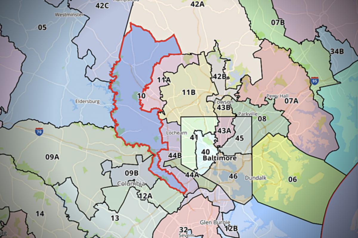
Baltimore County resident Linda Dorsey-Walker requested at a December public hearing that District 11 in Baltimore County, which is currently a multi-member district, be redrawn to include a single-member, majority Black district around Owings Mills.

“Owings Mills has 39,000 African Americans living in and around the area,” said Dorsey-Walker, who ran for the district in 2018 and finished fifth in a six-way primary. “That is almost enough for a single-member district by itself. Because of that, there is no particular reason why we should continue going on not having a minority elected.”

District 11 is currently represented by Democratic Dels. Lisa M. Belcastro, Jon S. Cardin and Dana M. Stein.

Commission Chair Karl Aro, a former head of the nonpartisan Department of Legislative Services, said at a virtual meeting Friday that the commission opted to include a single-member district around Owings Mills in response to that feedback and to comply with the federal Voting Rights Act.

There were other “minor changes” and tweaks to the proposed legislative map based on public feedback at the December hearing, Aro said, such as keeping a small area near Aberdeen in District 34 rather than moving it to District 35.

“It is based really on the districts that have been in existence for a long time, making the necessary changes for population, Voting Rights Act concerns,” and complying with constitutional requirements, Aro said.

Other changes the map makes from the current legislative districts include:

  • Allocating just four full state Senate districts wholly within Baltimore City, while a fifth shared with Baltimore County. The city lost population over the last decade, and currently contains five full state Senate districts and a portion of another.
  • District 9A, which currently includes roughly the northwestern half of Howard County and part of southern Carroll County, would lose Carroll County and instead extend into northern Montgomery County. The county retains eight state Senate districts in addition to gaining part of District 9.
  • The city of Frederick would remain contained within District 3, which would become a strong Democratic multi-member district that would be completely encircled by the Republican-leaning multi-member District 4.
  • Anne Arundel County’s District 33, which is currently a purplish district represented by Republican Sen. Edward R. Reilly, would be chopped into three subdistricts and become more favorable to Democrats.
  • In Baltimore County, District 8, traditionally a competitive district, appears to have become more Democratic, while District 42, which leans Republican, appears to have become more conservative.

Commission members ultimately voted to send the proposal to the General Assembly, with the four Democratic lawmakers on the commission in favor of the plan and the two Republican lawmakers against it.

Senate Minority Leader Bryan W. Simonaire (R-Anne Arundel) said he felt that map was “still gerrymandered” in voting against the proposal, and House Minority Leader Jason C. Buckel (R-Allegany) said he opposed the map because he supports more single-member House districts statewide.

“They best reflect the concept of one-person, one-vote,” Buckel said of single-member districts.

The Legislative Redistricting Advisory Commission was convened by Senate President Bill Ferguson (D-Baltimore City) and House Speaker Adrienne A. Jones (D-Baltimore County). Jones and Ferguson were both members of the commission alongside House Majority Leader Eric G. Luedtke (D-Montgomery) Senate President Pro Tem Melony G. Griffith (D-Prince George’s), Buckel and Simonaire.

Ferguson said continuity of representation was key in drawing the map, and noted that in the proposal “the overwhelming majority of Marylanders are in their existing districts.”

Lawmakers will take up the Legislative Redistricting Advisory Commission’s proposal when they kick off the regular legislative session next week. Also up for consideration will be the legislative proposal from the Maryland Citizens Redistricting Commission, a multi-partisan panel created by Gov. Lawrence J. Hogan Jr. (R) earlier this year to draw up congressional and legislative redistricting proposals that he would then submit to the General Assembly.

The Maryland Citizens Redistricting Commission’s congressional proposal did not advance out of committee during a special session in early December.

Maryland’s constitution requires the governor to submit a legislative redistricting proposal and allows the General Assembly 45 days to make their own changes. If lawmakers don’t agree on changes to the map, the governor’s proposal automatically becomes law. Constitutionally, Hogan can’t veto the General Assembly’s legislative maps.

By Bennett Leckrone
Filed Under: Maryland News Tagged With: districts, general assembly, legislative, Maryland, redistricting

At Public Hearing, Marylanders Request Changes to Commission’s Proposed Legislative Boundaries

December 23, 2021 by Maryland Matters

Share

The Legislative Redistricting Advisory Commission released its proposed state legislative map Monday evening — and by Wednesday afternoon, members of the public weighed in on how the proposal would affect their home districts.

Much of the testimony at Wednesday’s public hearing revolved around granular details of individual districts. Del. Christian J. Miele (R-Baltimore County) urged commission members to retain a small area near Aberdeen in District 34 rather than moving it to District 35; Baltimore County resident Linda Dorsey-Walker said commission members should draw a single-member delegate district around Owings Mills in District 11; Kevin Burke of Anne Arundel County criticized the way Severna Park is drawn in the proposed map and said the community is “carved up like a Christmas turkey.”

Reginald Benbow, a Baltimore resident who has launched a House campaign in District 43, said he was concerned that adding Towson in Baltimore County to the existing district, which currently includes parts of north-central Baltimore City, would dilute the voice of historically redlined and marginalized communities. He noted that the city lost population over the past decade, but said most of that population loss was in the eastern and western areas of the city.

“You just have the potential of a more affluent community in Towson mixed in with some of the affluent communities already from the 43rd district that could overwhelm the interest of some of the neighborhoods that have historically been marginalized,” Benbow said.

The commission released its legislative map Monday evening, and the deadline to sign up to testify at the public hearing was 10 a.m. Wednesday. Beth Hufnagel of the League of Women Voters said the amount of time the public had to analyze the map before the hearing was “woefully inadequate.”

Legislative redistricting in Maryland is subject to a slightly different set of rules compared to congressional redistricting, which was just handled in a special legislative session and is now subject of a legal challenge.

In writing legislative districts, the Maryland Constitution expressly requires respect for political and geographic boundaries, requires that delegate districts must be nested in senatorial districts, and allows for the use of both single- and multi-member delegate districts.

Additionally, lawmakers have more leeway over differences in population between legislative districts, compared to stringent margins required in congressional districting. Lawmakers are allowed to create population variances of plus or minus 5% in legislative districts — although Karl Aro, the chair of the Legislative Redistricting Advisory Commission and a former head of the nonpartisan Department of Legislative Services, said the new legislative maps keep that figure to plus or minus 4%.

Aro said this map keeps population variances smaller than previous legislative maps that he worked on while he worked for the Department of Legislative Services.

“In my previous four rounds of redistricting, this is the smallest maximum deviation that we’ve ever achieved,” Aro said.

Del. Jason C. Buckel (R-Allegany), the House minority leader and a member of the Legislative Redistricting Advisory Commission, questioned whether the new proposed District 4 would pass muster for compactness. The proposed District 4 would encompass much of Frederick County around the city of Frederick, which is contained within District 3, creating what Buckel described as a “donut effect.”

Aro said he didn’t think the proposed District 4 “is a compactness issue at all.”

By Bennett Leckrone

Filed Under: Maryland News Tagged With: commission, delegates, districts, hearing, legislative, Maryland, redistricting, senate

Md. Citizens Redistricting Commission Finalizes Congressional, Legislative Maps

November 4, 2021 by Maryland Matters

Share

The Maryland Citizens Redistricting Commission, created by Gov. Lawrence J. Hogan Jr. (R) to draw up maps that he will propose to the General Assembly, finalized its redistricting proposals at a Wednesday evening meeting.

Commission members voted 8-1 to approve of congressional maps and unanimously to approve legislative maps at the meeting. Those maps, which are available online, are vastly different from the state’s current configuration because commissioners started from scratch and didn’t use existing districts to begin with.

Commission members weren’t allowed to consider partisan district makeup when creating the maps, but their congressional maps received high marks for partisan fairness from the Princeton Gerrymandering Project. The congressional map creates six Democratic and two Republican districts as opposed to the current 7-1 configuration, according to the Princeton Gerrymandering Project’s Redistricting Report Card. That report also rated the commission’s state senate maps highly in October, although panelists have since made changes to the legislative map and the group hasn’t reviewed the finalized version yet.

The commission is composed of three Republicans, three Democrats and three unaffiliated voters, and has been conducting public hearings on redistricting since June. Hogan has said he will submit the commission’s maps to the General Assembly, where Democrats hold a veto-proof majority in both the House of Delegates and the Senate. Lawmakers have formed their own redistricting panel, the Legislative Redistricting Advisory Commission, to conduct public hearings and draw up congressional and legislative maps.

Here are a few takeaways from the Maryland Citizens Redistricting Commission’s final redistricting proposal:


County splits are minimized compared with current congressional maps

Keeping communities and neighborhoods intact was a common ask from residents throughout the commission’s public hearings, and commissioners said Wednesday evening that they tried to minimize county splits as much as possible in their proposed maps.

Under the state’s current congressional maps, Baltimore City is split between the 2nd, 3rd and 7th Districts. The city would be contained within a single congressional district alongside portions of northern Anne Arundel County in the commission’s proposed maps.

Commission member William Thomas (D), a Baltimore City resident, was the only commission member to vote against the congressional proposal. Thomas said he was “disappointed” that he received little feedback on the congressional maps from city residents, and added that he couldn’t be sure the map accurately reflected what Baltimore residents want in their congressional configuration. He said he would’ve preferred an east-west split for Baltimore in the commission’s maps.

Anne Arundel County, currently split between four congressional districts, would also be kept more intact: Aside from neighborhoods included in a district with Baltimore City, the county is contained within a single district with all of Howard County and a small portion of northern Calvert County in the proposed maps.

Baltimore County, which is also split between four congressional districts in current maps, would be split between two districts from north to south. The northern portions of the county are included with the Eastern Shore in the 1st District, and the southern half of the county has its own self-contained district.

Northern portions of Montgomery County are kept in a district with Western Maryland, although that district would include all of Frederick and Carroll counties. Most of Montgomery County would include a self-contained district extending from Germantown to east of Aspen Hill. The eastern portion of the county, including Silver Spring and White Oak, would be included in a district with northern Prince George’s county.

Roughly the southern half of Prince George’s County is included in a district with Charles, St. Mary’s and Calvert counties.

The legislative map includes both single- and multi-member delegate districts

In his executive order creating the commission earlier this year, Hogan said single-member delegate districts should be used in the map “to the extent possible.” After weeks of debate, panelists decided to use a mix of single- and multi-member districts based on population density.

Eighteen of 47 state Senate districts contain three-member delegate districts in the Maryland Citizens Redistricting Commission’s proposed maps.

The commission’s proposed delegate map generally includes multi-member House districts in counties with a population density of more than 2,000 per square mile, commission Co-Chair Walter Olson (R) previously said.

There are various exceptions to the use of multi-member districts in the commission’s map: Single-member districts are used as required by the federal Voting Rights Act to ensure representation of people of color, and a Senate district of fewer than 500 people per square mile that is in a county with a population density of more than 2,000 per square mile will have single-member House districts. That exclusion would affect the Agricultural Reserve in northern Montgomery County, which would include single-member districts.

Single-member House districts are also used in all districts that cross county lines except District 39, which crosses from Prince George’s County into Charles County, because the population on the Charles County side of the district is too low to “make up the core of a single-member district,” according to a previous email from Maryland Department of Planning Public Affairs Director Kristin R. Fleckenstein.

The Maryland constitution allows state delegate districts with between one and three members, and the state currently uses a mix of both single- and multi-member districts. Delegate districts must be nested within state Senate districts in Maryland, with three delegates per Senate district. Potential configurations include three single-member delegate districts within a Senate district; one single-member delegate district and a two-member delegate district; and one three-delegate district.

Multi-member districts are more widely used than single-member districts statewide in current legislative maps. Single-member districts are generally used in more rural or geographically large districts or when required by the Voting Rights Act. They are also sometimes used in current maps when a portion of a Senate district crosses county lines.

Proponents of single-member districts who testified during the Maryland Citizens Redistricting Commission’s three rounds of public hearings said they make it easier for political newcomers to challenge incumbents and create more specialized local representation, while proponents of multi-member districts have said they offer voters broader representation and helped the Maryland General Assembly outpace other states in terms of gender and racial diversity.

The MCRC maps are highly unlikely to be enacted

The General Assembly, where Democrats hold a veto-proof majority in both the House of Delegates and the Senate, will have the final say over redistricting in Maryland. Legislative leaders created their own commission, the bipartisan Legislative Redistricting Advisory Commission, to draw up their own set of congressional and legislative maps.

The legislative commission includes four Democratic and two Republican legislative leaders and is chaired by Karl Aro, the former director of the nonpartisan Department of Legislative Services. That panel kicked off its public hearings in September, but hasn’t produced congressional or legislative maps for public comment yet.

Hogan said last week that he would oppose maps from the General Assembly that “don’t follow what the Citizens Redistricting Commission has come up with.” The governor can veto congressional maps, but Democrats hold a veto-proof majority in both the House of Delegates and Senate and easily overrode his vetoes on several measures during the 2021 legislative session.

Lawmakers are planning a special session in December to tackle congressional redistricting. The Legislative Redistricting Advisory Commission is set to wrap up its hearings this month before recommending maps to the General Assembly.

By Bennett Leckrone

Filed Under: Maryland News Tagged With: commission, congressional, districts, legislative, Maryland, redistricting

Md. Citizens Redistricting Panel Starts Second Round Of Public Hearings, Draws Draft Map

September 13, 2021 by Maryland Matters

Share

The Maryland Citizens Redistricting Commission kicked off its second round of public hearings Thursday night, and drew up their first complete draft congressional map.

Commission members reviewed several draft maps of individual congressional districts drawn up by their resident redistricting expert, Nathaniel Persily, for “illustrative, instructional and potential discussion” purposes at the meeting.

Those maps mostly deal with individual regions of the state and are available online, but aren’t meant to reflect the commission’s final plans. Commission members also drew up a draft congressional map and agreed on a few general principles such as not crossing the Chesapeake Bay and creating a western Maryland district that includes Carroll County.

In addition to those principles, the draft map combines the three southern Maryland counties with southern Prince George’s County; combines most of Anne Arundel County with Howard County; keeps Baltimore City whole by combining it with portions of northern Anne Arundel County; and includes part of northern Montgomery County in the western Maryland district.

The draft map, which would add a second Republican-leaning district in western Maryland, generally features fewer county splits than the state’s current congressional maps. Baltimore is currently split between three congressional districts, and in the draft it is entirely contained within one. Anne Arundel County is currently split between four congressional districts, and is split between two in the draft map. Baltimore County also sees less splits in the draft.

The commission is still conducting public hearings and accepting map submissions for the public, so the draft map is likely to change.

The individual congressional districts included in the draft congressional map may be viewed in the pdf below.

2021-0909-individual-district-maps-for-draft-cong-plan


Just two speakers from the public testified at last week’s hearing: Zulieka Baysmore, a Baltimore resident who was a candidate in the 2020 Republican mayoral primary, and Reuben Collins, the Democratic president of the Charles County Board of Commissioners.

Collins noted that Charles County was one of the fastest-growing counties in Maryland, according to U.S. Census data, and said commission members should “look at amplifying opportunities for minority representation” in his county.

Baysmore urged commission members to keep districts competitive in their proposed maps rather than “fully red or fully blue.”

The commission has received 10 map submissions from the public to date, Maryland Department of Planning Director of Public Affairs Kristin Fleckenstein said at the meeting. The commission’s next virtual public hearings are set for 6 p.m. Monday, Sept. 13, and Tuesday, Sept. 14.

The Maryland Citizens Redistricting Commission was created via executive order by Gov. Lawrence J. Hogan Jr. (R) and includes three Republicans, three Democrats and three unaffiliated voters. The commission is tasked with drawing up congressional and legislative maps that Hogan plans to submit to the General Assembly.

The General Assembly, where Democrats hold a veto-proof majority in both the House of Delegates and the Senate, will have the final say over proposed maps. The Legislative Redistricting Advisory Commission announced Friday that it would hold its first public hearing at 6 p.m. Sept. 20 at Prince George’s Community College in Largo as part of its map-making process.

By Bennett Leckrone

Filed Under: Maryland News Tagged With: citizens, commission, congressional, legislative, Maryland, redistricting

Mid-Shore Saw Little Population Growth; QA’s County Added 2K Residents, Kent Lost 1K

September 8, 2021 by John Griep

Share

Although Maryland’s population increased nearly 7% between 2010 and 2020, population growth on the Mid-Shore was virtually stagnant. Queen Anne’s County accounted for most of the growth in the last decade; Kent County’s population decline was the highest in the region.

Census population numbers are used to “determine the number of seats each state has in the U.S. House of Representatives and is also used to distribute hundreds of billions of dollars in federal funds to local communities,” according to the U.S. Census Bureau.

The numbers are also used to draw state legislative districts and county-level districts for county council or commission and board of education where those seats are elected by district.

While much of the focus is on the congressional and state legislative districts, the 2020 population figures may require some small adjustments for county-level seats that are elected from districts.

Queen Anne’s County, with 2,000 more residents, likely will require the most adjustments for its county commission and school board seats, depending on where the new residents are distributed. Kent County does not elect members from districts for county commission or school board and will not need to make any adjustments despite losing nearly 1,000 residents.

Mid-Shore public bodies with districts include:

Caroline County — board of education, three districts;

Dorchester County — county council, five districts; board of education, five districts;

Queen Anne’s County — county commissioners, four districts, one at-large; board of education, four districts, one at-large;

Talbot County — board of education, seven districts.

The biggest battles will occur with the congressional and state legislative district maps. Maryland’s current congressional map is considered one of the most gerrymandered in the nation. Gov. Martin O’Malley and Democratic lawmakers packed Democratic areas into a western Maryland district that had repeatedly elected a Republican to Congress. The mapping process following the 201o Census also put more Republicans into the First District, which encompasses the Eastern Shore.

As a result, Maryland’s congressional representation went from six Democrats and two Republicans to seven Democrats and one Republican (the First District’s Andy Harris).

Two redistricting commissions — one appointed by Gov. Larry Hogan and another by Maryland legislative leaders — are already at work on the maps for the congressional and legislative district maps.

The state planning department offers adjusted redistricting data on its website, which also includes a link to a mapping web portal through which anyone may submit proposed redistricting maps for review by the Maryland Citizens Redistricting Commission appointed by Hogan.

Outside groups also have offered maps, with several available to view at Dave’s Redistricting, “a free web app to create, view, analyze and share redistricting maps for all 50 states and the District of Columbia, according to the site.

The website offers five notable maps — most proportional, most competitive, best minority representation, most compact, and least splitting — for congressional, state senate, and state house redistricting plans.

At presstime, the notable congressional maps for proportionality, competitiveness, and compactness would split the Eastern Shore into two districts. The First Congressional District currently includes the entire Eastern Shore from Cecil to Worcester county and portions of Harford, Baltimore, and Carroll counties.

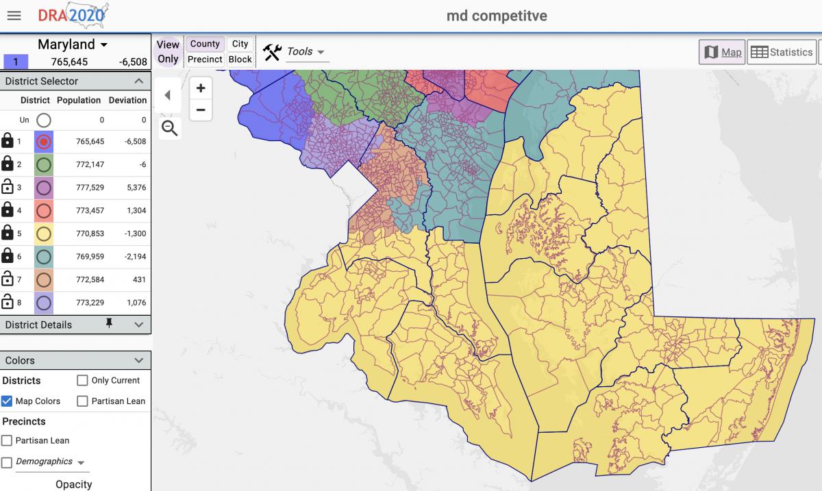
The current most proportional and most competitive congressional map would create a district that includes Queen Anne’s to Worcester county on the Eastern Shore, the southern Maryland counties of Calvert, Charles, and St. Mary’s, and a portion of Prince George’s County. That district is seen in yellow below.

The most proportional and most competitive Maryland congressional district maps published thus far would include seven Eastern Shore counties, three southern Maryland counties, and a portion of Prince George’s County. Screenshot from Dave’s Redistricting.

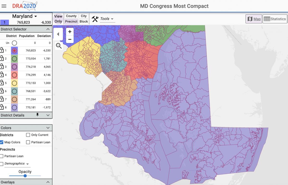
The most compact congressional map has a district that includes Kent to Worcester county, the three southern Maryland counties, and portions of Prince George’s and Anne Arundel counties. That district is seen in light purple below.

The most compact Maryland congressional district maps published thus far would include eight Eastern Shore counties, three southern Maryland counties, and portions of Prince George’s and Anne Arundel counties. Screenshot from Dave’s Redistricting.

Filed Under: News Homepage Tagged With: census, congressional, county, districts, legislative, maps, Maryland, mid-shore, population, redistricting, school board

It’s Map Drawing Time. Citizens Redistricting Commission Opens Public Submissions

September 3, 2021 by Maryland Matters

Share

Marylanders can now submit their own proposals for redistricting to the Maryland Citizens Redistricting Commission, state officials announced Thursday.

The Maryland Department of Planning’s new submission portal allows users to map their proposals for congressional and state legislative districts, and includes instructions on how to draw districts.

Members of the Maryland Citizens Redistricting Commission will review maps that are received by noon on Sept. 24, according to the planning department. More submissions will be accepted when that panel begins its third round of hearings in October.

The map submission portal uses redistricting data which counts incarcerated Marylanders as residents of their last known address, as required by Maryland law, according to the release.

The nine-member commission — which includes three Democrats, three Republicans and three unaffiliated voters — is set to start a new round of public hearings on Sept. 9. That hearing will be virtual.

The commission worked with Stanford Law School professor Nathaniel Persily to hash out some rough criteria for maps on Wednesday. Although the commission won’t make its redistricting proposal for some time and will consider citizens’ proposals, members said they hope to have some early drafts ready for public comment by next week.

Commission members also mulled whether to keep the Eastern Shore whole or cross the Chesapeake Bay to create a district consisting of part of Southern Maryland and the Lower Shore. Commission Member Kimberly Rose Cummings (R), a Dorchester County resident, noted that some Lower Shore residents told panelists, during an initial round of public hearings, that they have more in common with Southern Maryland residents than with residents of north and central Maryland.

There is historical precedent for crossing the Chesapeake Bay in a congressional district, as the state’s 1st Congressional District once included portions of Southern Maryland as well as the entire Eastern Shore from the early 1970s to the early 1990s. The 1st District currently includes all of Maryland’s Eastern Shore and portions of Baltimore, Harford and Carroll countries.

Commission Co-chair Alexander Williams Jr. (D), a Prince George’s County resident and retired federal judge, said that rapidly developing Charles County has more in common with parts of Prince George’s County than with other parts of Southern Maryland. Commission members chose to leave both options on the table for public comment and map submissions.

As for drawing a district in Western Maryland, commission Co-chair Walter Olson (R) said the panel should look to include Carroll County with Frederick, Garrett and Allegany counties. Olson and Williams served on an emergency commission to redraw the state’s 6th Congressional District before the Supreme Court reversed a 2018 order to redraw the district. Olson said that, during the emergency commission’s run, Carroll County residents “overwhelmingly” asked to be included in a Western Maryland district.

Whether the Western Maryland district would draw from portions of northern Montgomery or Howard counties remains an open question for commission members.

None of the commission’s initial criteria are set in stone, rather they are meant to be a baseline for public comment during upcoming public hearings.

Gov. Lawrence J. Hogan Jr. (R) created the Maryland Citizens Redistricting Commission via executive order to draw congressional and legislative maps that he will propose to the General Assembly. Democrats hold a veto-proof majority in both the House of Delegates and the Senate, and lawmakers will have the final say over the state’s next set of maps.

Senate President Bill Ferguson (D-Baltimore City) and House Speaker Adrienne A. Jones (D-Baltimore County) created their own bipartisan redistricting commission, the Legislative Redistricting Advisory Commission, to draw congressional and legislative maps. The legislative commission held its first meeting this week and is set to kick off a statewide round of public hearings on Sept. 20 with a hearing focused on Prince George’s County.

By Bennett Leckrone

Filed Under: Maryland News Tagged With: census, commission, congressional, districts, legislative, maps, Maryland, redistricting

Md. Citizens Redistricting Commission Brings on National Election Law Expert as Consultant

August 27, 2021 by Maryland Matters

Share

The Maryland Citizens Redistricting Commission is bringing on Nathaniel Persily, a nationally recognized expert on redistricting, to help draw up their congressional and legislative maps.

Commission Co-chair Walter Olson, a senior fellow at Cato Institute’s Robert A. Levy Center for Constitutional Studies, announced at a Wednesday night meeting that Persily would serve as the panel’s adviser. He called Persily an “eminent” figure in the field of redistricting.

Redistricting expert Nathaniel Persily

Persily, the James B. McClatchy Professor of Law at Stanford Law School, previously served as a court-appointed expert for the redrawing of Maryland’s legislative plan in 2002. He has also been appointed by courts to help redraw legislative or congressional districts in Connecticut, Georgia, New York and North Carolina.

Persily will serve as the commission’s chief map-drawer and resident redistricting expert, and will use the panel’s input to craft congressional and legislative maps.

Persily is advising commissions across the country as part of the current round of redistricting — including the Prince George’s County Redistricting Commission. His role will be paid, Department of Planning spokeswoman Kristin Fleckenstein said in an email, but an exact funding figure wasn’t immediately available Wednesday night.

The multi-partisan Maryland Citizens Redistricting Commission was created by Gov. Lawrence J. Hogan Jr. (R) to draw up congressional and legislative maps that he will propose to the General Assembly. Lawmakers will have the final say over what the state’s next set of maps look like, and Democrats hold a veto-proof majority in both the House of Delegates and the Senate.

House Speaker Adrienne A. Jones (D-Baltimore County) and Senate President Bill Ferguson (D-Baltimore City) announced their own bipartisan redistricting commission earlier this summer. That commission is chaired by former Department of Legislative Services Executive Director Karl Aro, who was appointed alongside Persily to redraw the state’s legislative maps after a 2002 lawsuit overturned the state’s legislative map.

Both of the commissions are planning to hold public hearings after Census redistricting data is adjusted to comply with Maryland law by having incarcerated individuals reallocated to their last known address. Fleckenstein said at the meeting that the data is expected to be ready next week.

By Bennett Leckrone

Filed Under: Maryland News Tagged With: congressional, expert, legislative, maps, Maryland, nathaniel persily, redistricting

Analysis: Census Data and the Political Reordering to Come in Md.

August 16, 2021 by Maryland Matters

Share

Baltimore City leaders knew they were coming.

And yet, the newest population numbers from the U.S. Census, delivered Thursday on the hottest day of the year, hit them like a torrent of cold water in the face.

Baltimore’s dramatic 5.7% population loss over the past 10 years means the city is sure to face a corresponding loss of political clout in the decade ahead — no matter how many allies it has in the highest echelons of power in Annapolis.

That’s one of many political threads that will be pulled over the next several months, as state politicians and policymakers seek to use the Census data as part of the recipe for congressional and legislative district maps that will be in place until the elections of 2032.

Baltimore wasn’t the only Maryland jurisdiction to see significant population losses — far from it. But the latest numbers did produce a significant degree of handwringing in the city.

Donald C. Fry, president and CEO of the business group the Greater Baltimore Committee, called it “unacceptable for a city with the many positive attributes Baltimore has, from its affordability, diversity, strong neighborhoods, historical and cultural attractions to world class healthcare and universities, to lose residents.”

Baltimore Mayor Brandon M. Scott (D) scrambled to put the dreary numbers in historical context and asserted that city leaders are putting policies in place to stanch the bleeding and slowly build back the city’s population.

“Today’s population figures are the culmination of more than 70 years of population decline, showing why we must pivot from the status quo towards inclusive economic policies that improve the lives of our legacy residents, while attracting new residents,” Scott said Thursday. “Understanding that much of Baltimore’s 21st century population loss has been driven by an exodus of African American households, my administration will be focused on equitable economic development. We can no longer leave any corner of our city behind.”

Census figures help determine how much federal aid is distributed to states and local jurisdictions, but they are also key weapons in the raw redistricting political battles that will follow.

Overlaying Maryland’s current congressional and legislative district maps with the map of of the latest county-by-county population trends is an interesting exercise.

Even the most gerrymandered political maps must start at the corners of the state — far Western Maryland and the Lower Eastern Shore. And at both poles of the state, the population, with the exception of Wicomico County on the Shore, has declined over the past decade. That’s part of a national trend that saw rural population drop sharply while it increased in urban and suburban areas — and will have implications for what congressional and legislative boundaries in Maryland look like.

From the minute he took office, Gov. Lawrence J. Hogan Jr. (R) has sought to inject himself in the redistricting process — or at least take the power away from the Democratic supermajorities in the General Assembly and, by extension, the most senior Democrats in the state’s congressional delegation. But the fact remains that legislative leaders, working in tandem with U.S. House Majority Leader Steny H. Hoyer (D-Md.), will have the most say.

For State House Democrats, knowing that Republican legislatures will attempt to help the GOP seize control of the U.S. House of Representatives by muscling through baldly gerrymandered maps, there will be temptations to create an 8-0 Democratic congressional map in Maryland (the state delegation currently has seven Democrats and one Republican). But the Census figures show that population trends in certain red states weren’t as stark as they could have been — meaning Republicans won’t have quite as much power to bludgeon Democrats in those places as they might have expected.

“Early read: based on the strong urban and weaker rural numbers I’m seeing, this is a much more favorable Census count than minority advocacy groups/Dems had feared,” Dave Wasserman, the House analyst for the nonpartisan Cook Political Report tweeted Thursday.

As a result, Maryland Democratic strategists believe, party leaders are more likely to try to produce a 7-1 Democratic congressional map again — albeit one that is cleaner, with fewer tortured contours, and that is less susceptible to lawsuit than the post-2010 Census map.

Baltimore City currently has three congressional districts cutting through its borders. Anne Arundel County has four. Howard County has three. Baltimore County has four. The result is messy, nonsensical districts in the central part of the state. That may change.

With population losses on the Eastern Shore, the 1st Congressional District, held by the state’s lone Republican member of Congress, Rep. Andrew P. Harris, will probably need to gain more territory on the western side of the Chesapeake Bay. Where those precincts are added may determine how competitive a re-election race Harris will face in 2022 — most likely against former state Del. Heather R. Mizeur (D).

Maryland mapmakers actually have more flexibility when it comes to drawing legislative districts — where population variations of as much as 10% are permissible (each congressional district must contain the exact same population, to the extent possible). Even so, Baltimore City, which has steadily lost representation over the past few decades, is likely to lose more seats.

It’s already accepted wisdom in Annapolis that the 44th District, which currently contains a one-member House subdistrict in Baltimore City and two House seats in Baltimore County, will push out into the county exclusively — meaning the legislative tenure of Roxane Prettyman (D), who has been recommended by the Baltimore City Democratic Central Committee to fill a vacancy in District 44A, could be short-lived.

Another Baltimore City legislative district that has seen modest population growth, District 46, may have to lose some city precincts to make whole other city districts — and could extend south toward Glen Burnie or even BWI Thurgood Marshall Airport.

Howard County’s population growth means it may no longer have to share one legislative district with Baltimore County. Frederick County’s population growth means it may not have to share a legislative district with Carroll County. Southern Maryland’s representation in Annapolis is also likely to grow — though Democrats undoubtedly will try to maximize their advantage in fast-growing Charles County, which, according to the latest Census figures, is now over 50% Black.

And population losses in Garrett and Allegany counties mean the 1st legislative district will necessarily have to push farther east into Washington County.

The Maryland Department of Planning will now take the Census figures and spend the next few weeks adjusting them to account for the state’s incarcerated population. Under state law, incarcerated individuals are countered as residents of the jurisdictions where they previously lived, rather than the jurisdiction of the prisons where they are serving their sentences. This could help limit Baltimore City’s population loss to a small degree.

Hogan and legislative leaders are relying on the work of dueling redistricting commissions to help guide them on the maps they will propose in an upcoming special session of the General Assembly to finalize a congressional map, and during the regular 2022 session when legislative lines must be adopted. Even though Democrats have the upper hand, Hogan was already attempting to grab the moral high ground on Thursday.

“All across our state, Marylanders are demanding an end to partisan gerrymandering from partisan politicians in the legislature and supporting the work of the independent and nonpartisan Maryland Citizens Redistricting Commission,” he said on Twitter.

By Josh Kurtz

Filed Under: Maryland News Tagged With: 2020, census, congressional, districts, gerrymandering, legislative, Maryland, redistricting

Copyright © 2023

Affiliated News

  • The Cambridge Spy
  • The Talbot Spy

Sections

  • Arts
  • Culture
  • Ecosystem
  • Education
  • Health
  • Local Life and Culture
  • Spy Senior Nation

Spy Community Media

  • About
  • Subscribe
  • Contact Us
  • Advertising & Underwriting

Copyright © 2023 · Spy Community Media Child Theme on Genesis Framework · WordPress · Log in