MENU

Sections

  • Home
  • About
    • The Chestertown Spy
    • Contact Us
    • Advertising & Underwriting
      • Advertising Terms & Conditions
    • Editors & Writers
    • Dedication & Acknowledgements
    • Code of Ethics
    • Chestertown Spy Terms of Service
    • Technical FAQ
    • Privacy
  • The Arts and Design
  • Local Life and Culture
  • Public Affairs
    • Ecosystem
    • Education
    • Health
  • Community Opinion
  • Donate to the Chestertown Spy
  • Free Subscription
  • Talbot Spy
  • Cambridge Spy

More

  • Support the Spy
  • About Spy Community Media
  • Advertising with the Spy
March 28, 2023

The Chestertown Spy

An Educational News Source for Chestertown Maryland

  • Home
  • About
    • The Chestertown Spy
    • Contact Us
    • Advertising & Underwriting
      • Advertising Terms & Conditions
    • Editors & Writers
    • Dedication & Acknowledgements
    • Code of Ethics
    • Chestertown Spy Terms of Service
    • Technical FAQ
    • Privacy
  • The Arts and Design
  • Local Life and Culture
  • Public Affairs
    • Ecosystem
    • Education
    • Health
  • Community Opinion
  • Donate to the Chestertown Spy
  • Free Subscription
  • Talbot Spy
  • Cambridge Spy
News Maryland News

At Public Hearing, Marylanders Request Changes to Commission’s Proposed Legislative Boundaries

December 23, 2021 by Maryland Matters

Share

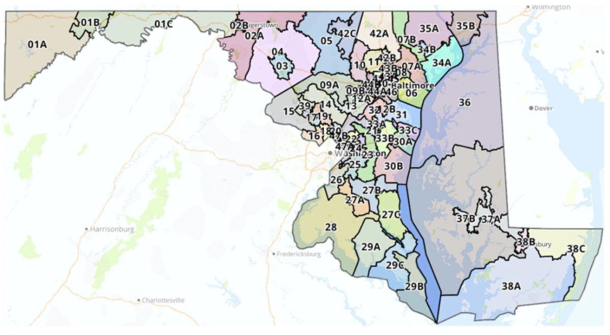
The Legislative Redistricting Advisory Commission released its proposed state legislative map Monday evening — and by Wednesday afternoon, members of the public weighed in on how the proposal would affect their home districts.

Much of the testimony at Wednesday’s public hearing revolved around granular details of individual districts. Del. Christian J. Miele (R-Baltimore County) urged commission members to retain a small area near Aberdeen in District 34 rather than moving it to District 35; Baltimore County resident Linda Dorsey-Walker said commission members should draw a single-member delegate district around Owings Mills in District 11; Kevin Burke of Anne Arundel County criticized the way Severna Park is drawn in the proposed map and said the community is “carved up like a Christmas turkey.”

Reginald Benbow, a Baltimore resident who has launched a House campaign in District 43, said he was concerned that adding Towson in Baltimore County to the existing district, which currently includes parts of north-central Baltimore City, would dilute the voice of historically redlined and marginalized communities. He noted that the city lost population over the past decade, but said most of that population loss was in the eastern and western areas of the city.

“You just have the potential of a more affluent community in Towson mixed in with some of the affluent communities already from the 43rd district that could overwhelm the interest of some of the neighborhoods that have historically been marginalized,” Benbow said.

The commission released its legislative map Monday evening, and the deadline to sign up to testify at the public hearing was 10 a.m. Wednesday. Beth Hufnagel of the League of Women Voters said the amount of time the public had to analyze the map before the hearing was “woefully inadequate.”

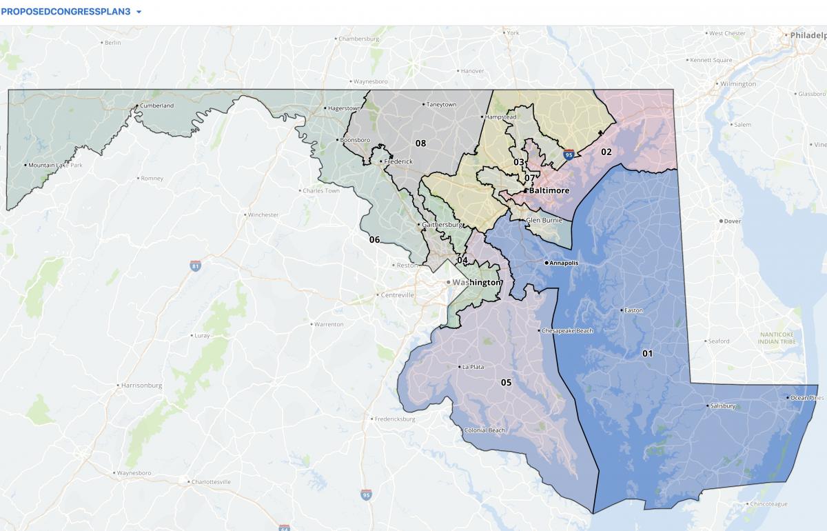
Legislative redistricting in Maryland is subject to a slightly different set of rules compared to congressional redistricting, which was just handled in a special legislative session and is now subject of a legal challenge.

In writing legislative districts, the Maryland Constitution expressly requires respect for political and geographic boundaries, requires that delegate districts must be nested in senatorial districts, and allows for the use of both single- and multi-member delegate districts.

Additionally, lawmakers have more leeway over differences in population between legislative districts, compared to stringent margins required in congressional districting. Lawmakers are allowed to create population variances of plus or minus 5% in legislative districts — although Karl Aro, the chair of the Legislative Redistricting Advisory Commission and a former head of the nonpartisan Department of Legislative Services, said the new legislative maps keep that figure to plus or minus 4%.

Aro said this map keeps population variances smaller than previous legislative maps that he worked on while he worked for the Department of Legislative Services.

“In my previous four rounds of redistricting, this is the smallest maximum deviation that we’ve ever achieved,” Aro said.

Del. Jason C. Buckel (R-Allegany), the House minority leader and a member of the Legislative Redistricting Advisory Commission, questioned whether the new proposed District 4 would pass muster for compactness. The proposed District 4 would encompass much of Frederick County around the city of Frederick, which is contained within District 3, creating what Buckel described as a “donut effect.”

Aro said he didn’t think the proposed District 4 “is a compactness issue at all.”

By Bennett Leckrone

Filed Under: Maryland News Tagged With: commission, delegates, districts, hearing, legislative, Maryland, redistricting, senate

Marylanders Urge Redistricting Commission To Draw More Competitive 1st Congressional District

November 17, 2021 by Maryland Matters

Share

Marylanders said the state’s solidly Republican 1st Congressional District should be redrawn to be more competitive at a Monday evening Legislative Redistricting Advisory Commission hearing, citing U.S. Rep. Andrew P. Harris’ vote earlier this year against certifying the 2020 presidential election results.

Harris, the state’s lone Republican in Congress, was among a majority of U.S. House Republicans who objected to certifying the 2020 presidential election results after the insurrection at the U.S. Capitol on Jan. 6. People who testified at Monday’s meeting cited that vote, alongside Harris’ vote against awarding Congressional Gold Medals to police officers who protected the Capitol that day, as reasons to draw a more competitive 1st District.

The Legislative Redistricting Advisory Commission (LRAC) released four “concept” congressional maps last week. While two of those maps would likely maintain Democrats’ current 7-1 advantage in the state, two would combine the Eastern Shore with portions of Anne Arundel County to create a more competitive 1st District.

“The existing congressional map has empowered an extremist to represent us with little fear of retribution for any of his actions or comments,” Queen Anne’s County resident Peter Behringer said at a statewide virtual LRAC hearing Monday.

Behringer said lawmakers should draw up a 1st District that is “competitive and balanced” and empowers people of color.

Those who testified overwhelmingly supported Plan 3, boundaries proposed by the commission that include a large portion of Anne Arundel County with the Eastern Shore and is the closest to an 8-0 Democratic map. That plan would include a 1st District that would favor Democrats 55%-45%, according to an analysis by the Princeton Gerrymandering Project.

Plan 2, which includes a smaller portion of Anne Arundel County with the Eastern Shore, would favor Democrats 51% to 49%, according to the analysts at Princeton. The Princeton Gerrymandering Project gave all four maps a failing grade after researchers rated them based on “partisan fairness,” “competitiveness” and “geographic features.”

Harris has handily won re-election bids in the 1st District since he ousted Democratic Rep. Frank Kratovil by a wide margin in the 2010 election, and garnered 63.4% of the vote against challenger Mia Mason’s 36.4% in the 2020 election. His current Democratic challengers include former state Del. Heather R. Mizeur and foreign policy strategist R. David Harden.

The 1st District currently includes the entire Eastern Shore before looping north to include parts of Harford, Baltimore and Carroll counties.

“He can lean extremely far to the right since the current map stacks Republicans together in District 1,” Felicia Martin, a Harford County resident, said. “Districts should be drawn so that representatives can contemplate a spectrum of issues and be willing to work with both parties.”

Judy Wixted, an Eastern Shore resident, said Plan 3 is “somewhat acceptable,” but added that she doesn’t think the plan goes far enough to challenge Harris.

“This district, as it was drawn ten years ago, packed MD-1 in such a way that only the most radical Republican could win a primary,” she said.

Mason likewise urged lawmakers to draw a more competitive 1st District at the meeting, and also noted the vast geographic size of the district as it’s currently drawn, comparing it to “two Delawares.”

Some who testified at the meeting said it makes sense to combine the Eastern Shore with Anne Arundel County, since the regions are connected by the Chesapeake Bay Bridge. Marnette Finn, an Anne Arundel County resident, said the Eastern Shore is linked “culturally and economically” with Anne Arundel County because of the bridge. She said it makes more sense to connect the Eastern Shore with the rest of Maryland at the bridge rather than by going north through Harford County.

“Both regions have the same economic and environmental interest in protecting the Bay,” Finn said.

Paul Berman noted that Gov. Lawrence J. Hogan Jr. (R) has said he wants the planned third span of the Chesapeake Bay Bridge to be built at the current site.

“Governor Hogan’s insistence on expanding the connection between the Eastern Shore and Anne Arundel County offers clear confirmation of this commission’s [Plan 3]. Linking the Eastern Shore with Annapolis and a large portion of Anne Arundel County would provide the best configuration for Maryland’s 1st Congressional District,” Berman said.

The congressional map proposed by Hogan’s Maryland Citizens Redistricting Commission (MCRC) keeps the Eastern Shore linked with parts of northern Maryland. That map received high marks from the Princeton Gerrymandering Project for partisan fairness, and Hogan has said he will oppose any maps from the General Assembly that differ from the MCRC’s proposal.

While Hogan could veto congressional maps, Democrats hold a veto-proof majority in both the House of Delegates and the State Senate and have complete control over the redistricting process in Maryland. Lawmakers are set to tackle congressional redistricting at a special session beginning Dec. 6.

Maryland’s current congressional district map was challenged as an illegal partisan gerrymander in federal court and considered by the Supreme Court twice, with justices ultimately decided not to set a standard for what constitutes extreme gerrymandering.

By Bennett Leckrone

Filed Under: Maryland News Tagged With: andy harris, commission, competitive, Congress, first district, Maryland, redistricting

Md. Citizens Redistricting Commission Finalizes Congressional, Legislative Maps

November 4, 2021 by Maryland Matters

Share

The Maryland Citizens Redistricting Commission, created by Gov. Lawrence J. Hogan Jr. (R) to draw up maps that he will propose to the General Assembly, finalized its redistricting proposals at a Wednesday evening meeting.

Commission members voted 8-1 to approve of congressional maps and unanimously to approve legislative maps at the meeting. Those maps, which are available online, are vastly different from the state’s current configuration because commissioners started from scratch and didn’t use existing districts to begin with.

Commission members weren’t allowed to consider partisan district makeup when creating the maps, but their congressional maps received high marks for partisan fairness from the Princeton Gerrymandering Project. The congressional map creates six Democratic and two Republican districts as opposed to the current 7-1 configuration, according to the Princeton Gerrymandering Project’s Redistricting Report Card. That report also rated the commission’s state senate maps highly in October, although panelists have since made changes to the legislative map and the group hasn’t reviewed the finalized version yet.

The commission is composed of three Republicans, three Democrats and three unaffiliated voters, and has been conducting public hearings on redistricting since June. Hogan has said he will submit the commission’s maps to the General Assembly, where Democrats hold a veto-proof majority in both the House of Delegates and the Senate. Lawmakers have formed their own redistricting panel, the Legislative Redistricting Advisory Commission, to conduct public hearings and draw up congressional and legislative maps.

Here are a few takeaways from the Maryland Citizens Redistricting Commission’s final redistricting proposal:


County splits are minimized compared with current congressional maps

Keeping communities and neighborhoods intact was a common ask from residents throughout the commission’s public hearings, and commissioners said Wednesday evening that they tried to minimize county splits as much as possible in their proposed maps.

Under the state’s current congressional maps, Baltimore City is split between the 2nd, 3rd and 7th Districts. The city would be contained within a single congressional district alongside portions of northern Anne Arundel County in the commission’s proposed maps.

Commission member William Thomas (D), a Baltimore City resident, was the only commission member to vote against the congressional proposal. Thomas said he was “disappointed” that he received little feedback on the congressional maps from city residents, and added that he couldn’t be sure the map accurately reflected what Baltimore residents want in their congressional configuration. He said he would’ve preferred an east-west split for Baltimore in the commission’s maps.

Anne Arundel County, currently split between four congressional districts, would also be kept more intact: Aside from neighborhoods included in a district with Baltimore City, the county is contained within a single district with all of Howard County and a small portion of northern Calvert County in the proposed maps.

Baltimore County, which is also split between four congressional districts in current maps, would be split between two districts from north to south. The northern portions of the county are included with the Eastern Shore in the 1st District, and the southern half of the county has its own self-contained district.

Northern portions of Montgomery County are kept in a district with Western Maryland, although that district would include all of Frederick and Carroll counties. Most of Montgomery County would include a self-contained district extending from Germantown to east of Aspen Hill. The eastern portion of the county, including Silver Spring and White Oak, would be included in a district with northern Prince George’s county.

Roughly the southern half of Prince George’s County is included in a district with Charles, St. Mary’s and Calvert counties.

The legislative map includes both single- and multi-member delegate districts

In his executive order creating the commission earlier this year, Hogan said single-member delegate districts should be used in the map “to the extent possible.” After weeks of debate, panelists decided to use a mix of single- and multi-member districts based on population density.

Eighteen of 47 state Senate districts contain three-member delegate districts in the Maryland Citizens Redistricting Commission’s proposed maps.

The commission’s proposed delegate map generally includes multi-member House districts in counties with a population density of more than 2,000 per square mile, commission Co-Chair Walter Olson (R) previously said.

There are various exceptions to the use of multi-member districts in the commission’s map: Single-member districts are used as required by the federal Voting Rights Act to ensure representation of people of color, and a Senate district of fewer than 500 people per square mile that is in a county with a population density of more than 2,000 per square mile will have single-member House districts. That exclusion would affect the Agricultural Reserve in northern Montgomery County, which would include single-member districts.

Single-member House districts are also used in all districts that cross county lines except District 39, which crosses from Prince George’s County into Charles County, because the population on the Charles County side of the district is too low to “make up the core of a single-member district,” according to a previous email from Maryland Department of Planning Public Affairs Director Kristin R. Fleckenstein.

The Maryland constitution allows state delegate districts with between one and three members, and the state currently uses a mix of both single- and multi-member districts. Delegate districts must be nested within state Senate districts in Maryland, with three delegates per Senate district. Potential configurations include three single-member delegate districts within a Senate district; one single-member delegate district and a two-member delegate district; and one three-delegate district.

Multi-member districts are more widely used than single-member districts statewide in current legislative maps. Single-member districts are generally used in more rural or geographically large districts or when required by the Voting Rights Act. They are also sometimes used in current maps when a portion of a Senate district crosses county lines.

Proponents of single-member districts who testified during the Maryland Citizens Redistricting Commission’s three rounds of public hearings said they make it easier for political newcomers to challenge incumbents and create more specialized local representation, while proponents of multi-member districts have said they offer voters broader representation and helped the Maryland General Assembly outpace other states in terms of gender and racial diversity.

The MCRC maps are highly unlikely to be enacted

The General Assembly, where Democrats hold a veto-proof majority in both the House of Delegates and the Senate, will have the final say over redistricting in Maryland. Legislative leaders created their own commission, the bipartisan Legislative Redistricting Advisory Commission, to draw up their own set of congressional and legislative maps.

The legislative commission includes four Democratic and two Republican legislative leaders and is chaired by Karl Aro, the former director of the nonpartisan Department of Legislative Services. That panel kicked off its public hearings in September, but hasn’t produced congressional or legislative maps for public comment yet.

Hogan said last week that he would oppose maps from the General Assembly that “don’t follow what the Citizens Redistricting Commission has come up with.” The governor can veto congressional maps, but Democrats hold a veto-proof majority in both the House of Delegates and Senate and easily overrode his vetoes on several measures during the 2021 legislative session.

Lawmakers are planning a special session in December to tackle congressional redistricting. The Legislative Redistricting Advisory Commission is set to wrap up its hearings this month before recommending maps to the General Assembly.

By Bennett Leckrone

Filed Under: Maryland News Tagged With: commission, congressional, districts, legislative, Maryland, redistricting

Shore Residents Say Legislative Redistricting Panel Should Boost Representation of People of Color

October 19, 2021 by Maryland Matters

Share

Eastern Shore residents urged members of the Legislative Redistricting Advisory Commission to boost representation for people of color in their legislative maps at a Monday evening public hearing.

Sonya Whited, a Wicomico County resident, said during a public hearing at the Todd Performing Arts Center in Wye Mills that the commission should look at drawing an additional single-member delegate district with a majority of people of color on the Eastern Shore in their proposed legislative maps in addition to District 37A, which is represented by House of Delegates Speaker Pro Tem Sheree Sample-Hughes (D).

“We are at the point where carving out one minority district represented by Delegate Sheree Sample-Hughes is not enough to truly address the concerns of other minority and sometimes marginalized communities,” Whited said. “I am hopeful that this critical district could be part of the fair map drawing process versus a court case.”

Patrick Firth, the chairman of the Talbot County Democratic Central Committee, said the panel could create an additional single-member district that would stretch from Salisbury University to the University of Maryland Eastern Shore, the historically Black university in Princess Anne.

“It’s time for the General Assembly to recognize the changing population and growing diversity (of) the Eastern Shore,” Firth said.

He also said Talbot County should be drawn into a single-member district with parts of Caroline Counties rather than a broader district with portions of the lower Eastern Shore.

Whited also said she wants the commission to largely keep multi-member delegate districts in their legislative maps. Maryland’s delegate maps currently contain a mix of single- and multi-member districts, with multi-member districts generally used in more densely populated areas and some rural areas including on the Eastern Shore. Whited and other proponents of multi-member districts say having multiple delegates gives voters access to legislators with different areas of expertise and broader representation.

Single-member districts are generally used in geographically larger and more rural districts or when required by the Voting Rights Act to ensure representation of people of color. They are also sometimes used when a portion of a senatorial district crosses county lines. Proponents of single-member delegate districts say they make it easier for political newcomers to challenge incumbents and also give voters a single point of contact in the House of Delegates.

Diana Waterman, a Queen Anne’s County resident and former state Republican Party chair, testified in favor of single-member districts at the public hearing, and argued that using single-member districts statewide “would ensure that all citizens receive the same level of service from their delegate.”

Waterman said the LRAC should consider supporting maps drawn up by the Maryland Citizens Redistricting Commission, a multi-partisan panel created by Gov. Lawrence J. Hogan Jr. (R) and tasked with drawing up congressional and legislative maps that he will propose to the General Assembly. That panel recently released draft delegate maps with both single- and multi-member districts based largely on population density, and will hold a virtual public hearing Wednesday at 6 p.m.

The General Assembly, where Democrats hold a veto-proof majority in both the House of Delegates and the Senate, will have the final say over the state’s next set of maps, and legislative leaders created the bipartisan LRAC to draw up their own set of maps.

Sen. Adelaide C. Eckardt (R-Lower Shore) said she supports single-member districts to ensure that individual counties have a shot at electing local delegates.

“Most of the counties want to make sure that they have somebody that lives in their district representing them,” Eckardt said.

Kathleen Bangert, speaking on behalf of several Eastern Shore chapters of the League of Women Voters, said her organization supports maintaining a mix of single- and multi-member districts in legislative maps.

“It is our position that the right mix of the two helps to promote full minority representation, preserve political and community boundaries, and encourage a more diverse candidate pool,” Bangert said.

Some Eastern Shore residents who testified at the public hearing also said the commission should look at crossing the Chesapeake Bay to include portions of Anne Arundel County with the Eastern Shore in congressional maps. The 1st Congressional District currently stretches into Harford, Carroll and Baltimore counties — but some who testified said Eastern Shore residents have more in common with Anne Arundel County because of the Chesapeake Bay Bridge.

“There is clearly a strong association between the Eastern Shore and Anne Arundel-related business and workforce development interests that impact our shared regional economy,” Chestertown resident Rebecca Flora said.

Tara Newman-Bell, a Talbot County resident, said in addition to ensuring that people of color’s voting power isn’t diluted and that maps aren’t drawn to favor any particular political party, commission members should provide clear rationale behind their eventual congressional and legislative maps.

By Bennett Leckrone

Filed Under: News Homepage, News Portal Highlights Tagged With: commission, Maryland, minority district, multi-member, redistricting, single member

Md. Citizens Redistricting Panel Starts Second Round Of Public Hearings, Draws Draft Map

September 13, 2021 by Maryland Matters

Share

The Maryland Citizens Redistricting Commission kicked off its second round of public hearings Thursday night, and drew up their first complete draft congressional map.

Commission members reviewed several draft maps of individual congressional districts drawn up by their resident redistricting expert, Nathaniel Persily, for “illustrative, instructional and potential discussion” purposes at the meeting.

Those maps mostly deal with individual regions of the state and are available online, but aren’t meant to reflect the commission’s final plans. Commission members also drew up a draft congressional map and agreed on a few general principles such as not crossing the Chesapeake Bay and creating a western Maryland district that includes Carroll County.

In addition to those principles, the draft map combines the three southern Maryland counties with southern Prince George’s County; combines most of Anne Arundel County with Howard County; keeps Baltimore City whole by combining it with portions of northern Anne Arundel County; and includes part of northern Montgomery County in the western Maryland district.

The draft map, which would add a second Republican-leaning district in western Maryland, generally features fewer county splits than the state’s current congressional maps. Baltimore is currently split between three congressional districts, and in the draft it is entirely contained within one. Anne Arundel County is currently split between four congressional districts, and is split between two in the draft map. Baltimore County also sees less splits in the draft.

The commission is still conducting public hearings and accepting map submissions for the public, so the draft map is likely to change.

The individual congressional districts included in the draft congressional map may be viewed in the pdf below.

2021-0909-individual-district-maps-for-draft-cong-plan


Just two speakers from the public testified at last week’s hearing: Zulieka Baysmore, a Baltimore resident who was a candidate in the 2020 Republican mayoral primary, and Reuben Collins, the Democratic president of the Charles County Board of Commissioners.

Collins noted that Charles County was one of the fastest-growing counties in Maryland, according to U.S. Census data, and said commission members should “look at amplifying opportunities for minority representation” in his county.

Baysmore urged commission members to keep districts competitive in their proposed maps rather than “fully red or fully blue.”

The commission has received 10 map submissions from the public to date, Maryland Department of Planning Director of Public Affairs Kristin Fleckenstein said at the meeting. The commission’s next virtual public hearings are set for 6 p.m. Monday, Sept. 13, and Tuesday, Sept. 14.

The Maryland Citizens Redistricting Commission was created via executive order by Gov. Lawrence J. Hogan Jr. (R) and includes three Republicans, three Democrats and three unaffiliated voters. The commission is tasked with drawing up congressional and legislative maps that Hogan plans to submit to the General Assembly.

The General Assembly, where Democrats hold a veto-proof majority in both the House of Delegates and the Senate, will have the final say over proposed maps. The Legislative Redistricting Advisory Commission announced Friday that it would hold its first public hearing at 6 p.m. Sept. 20 at Prince George’s Community College in Largo as part of its map-making process.

By Bennett Leckrone

Filed Under: Maryland News Tagged With: citizens, commission, congressional, legislative, Maryland, redistricting

It’s Map Drawing Time. Citizens Redistricting Commission Opens Public Submissions

September 3, 2021 by Maryland Matters

Share

Marylanders can now submit their own proposals for redistricting to the Maryland Citizens Redistricting Commission, state officials announced Thursday.

The Maryland Department of Planning’s new submission portal allows users to map their proposals for congressional and state legislative districts, and includes instructions on how to draw districts.

Members of the Maryland Citizens Redistricting Commission will review maps that are received by noon on Sept. 24, according to the planning department. More submissions will be accepted when that panel begins its third round of hearings in October.

The map submission portal uses redistricting data which counts incarcerated Marylanders as residents of their last known address, as required by Maryland law, according to the release.

The nine-member commission — which includes three Democrats, three Republicans and three unaffiliated voters — is set to start a new round of public hearings on Sept. 9. That hearing will be virtual.

The commission worked with Stanford Law School professor Nathaniel Persily to hash out some rough criteria for maps on Wednesday. Although the commission won’t make its redistricting proposal for some time and will consider citizens’ proposals, members said they hope to have some early drafts ready for public comment by next week.

Commission members also mulled whether to keep the Eastern Shore whole or cross the Chesapeake Bay to create a district consisting of part of Southern Maryland and the Lower Shore. Commission Member Kimberly Rose Cummings (R), a Dorchester County resident, noted that some Lower Shore residents told panelists, during an initial round of public hearings, that they have more in common with Southern Maryland residents than with residents of north and central Maryland.

There is historical precedent for crossing the Chesapeake Bay in a congressional district, as the state’s 1st Congressional District once included portions of Southern Maryland as well as the entire Eastern Shore from the early 1970s to the early 1990s. The 1st District currently includes all of Maryland’s Eastern Shore and portions of Baltimore, Harford and Carroll countries.

Commission Co-chair Alexander Williams Jr. (D), a Prince George’s County resident and retired federal judge, said that rapidly developing Charles County has more in common with parts of Prince George’s County than with other parts of Southern Maryland. Commission members chose to leave both options on the table for public comment and map submissions.

As for drawing a district in Western Maryland, commission Co-chair Walter Olson (R) said the panel should look to include Carroll County with Frederick, Garrett and Allegany counties. Olson and Williams served on an emergency commission to redraw the state’s 6th Congressional District before the Supreme Court reversed a 2018 order to redraw the district. Olson said that, during the emergency commission’s run, Carroll County residents “overwhelmingly” asked to be included in a Western Maryland district.

Whether the Western Maryland district would draw from portions of northern Montgomery or Howard counties remains an open question for commission members.

None of the commission’s initial criteria are set in stone, rather they are meant to be a baseline for public comment during upcoming public hearings.

Gov. Lawrence J. Hogan Jr. (R) created the Maryland Citizens Redistricting Commission via executive order to draw congressional and legislative maps that he will propose to the General Assembly. Democrats hold a veto-proof majority in both the House of Delegates and the Senate, and lawmakers will have the final say over the state’s next set of maps.

Senate President Bill Ferguson (D-Baltimore City) and House Speaker Adrienne A. Jones (D-Baltimore County) created their own bipartisan redistricting commission, the Legislative Redistricting Advisory Commission, to draw congressional and legislative maps. The legislative commission held its first meeting this week and is set to kick off a statewide round of public hearings on Sept. 20 with a hearing focused on Prince George’s County.

By Bennett Leckrone

Filed Under: Maryland News Tagged With: census, commission, congressional, districts, legislative, maps, Maryland, redistricting

General Assembly Leaders Announce Legislative Redistricting Commission

July 9, 2021 by Maryland Matters

Share

The Maryland General Assembly has launched its own commission to draw new congressional and legislative district maps.

Senate President Bill Ferguson (D-Baltimore City) and House Speaker Adrienne A. Jones (D-Baltimore County) announced the Legislative Redistricting Advisory Commission and its members in a Thursday press release.

The bipartisan commission will be chaired by Karl Aro, the former executive director of the non-partisan Department of Legislative Services. Ferguson and Jones will also sit on the commission, alongside four other lawmakers:

  • Senate President Pro Tempore Melony Griffith (D-Prince George’s County);
  • House Majority Leader Eric Luedtke (D-Montgomery County);
  • Senate Minority Leader Bryan W. Simonaire (R-Anne Arundel County); and
  • House Minority Leader Jason Buckel (R-Allegany County).

Commission members will “focus on developing new map configurations to best account for Maryland’s seven percent population growth,” according to the release.

Jones and Ferguson pledged a bipartisan and transparent redistricting process in Thursday’s release. The commission will hold 10 in-person town hall meetings across the state and two virtual meetings beginning in August. Those meetings will be live-streamed, according to the release.

Jones said in the release that the commission’s goal will be to “ensure that Maryland’s representation reflects its citizens.”

“The General Assembly will pass fair maps based on the robust public engagement and feedback of this Commission,” Jones said.

Ferguson said public input will be a virtual part of the commission’s work.

“We believe it is critical to hear from those we represent, and the Legislative Redistricting Advisory Commission serves as the General Assembly’s vehicle to hear from Marylanders across the State in a bipartisan and transparent manner before proposing maps for the Legislature to consider,” Ferguson said in a written statement. “The Commission is an essential step in the redistricting process to ensure fair representation for Maryland’s democracy.”

The commission’s formation comes as the multi-partisan Maryland Citizens Redistricting Commission — formed by Gov. Lawrence J. Hogan (R) earlier this year to draw up maps he will propose to the General Assembly — is already conducting a round of public hearings ahead of the release of Census redistricting data.

That nine-member commission, made up of three Republicans, three Democrats and three non-affiliated voters, has held hearings for the Baltimore City and Harford and Anne Arundel Counties, the Eastern Shore and the western, northern and southern regions of the state. During those hearings, residents have repeatedly urged commission members to keep communities whole in proposed maps.

“Governor Hogan has handed over his power to a citizens advisory commission to ensure it’s the people of Maryland who are drawing the maps — not politicians or party bosses in back rooms. The citizens commission has already held several public meetings across the state, gaining direct input from Marylanders,” Hogan spokesman Michael Ricci said Thursday evening.

Former Howard County Executive Allan Kittleman (R) and former state Sen. James Brochin (D-Baltimore County) – who recently formed the group Fair Maps Maryland alongside former Hogan communications strategist Doug Mayer to urge the General Assembly to adopt maps from the Maryland Citizens Redistricting Commission, criticized the formation of the legislative commission in a Thursday statement.

“This is real simple – politicians shouldn’t be drawing their own districts and picking their own voters, and unfortunately this new commission does exactly that,” the pair said.

Joanne Antoine, the executive director of the fair elections group Common Cause Maryland, said she would’ve liked to see members of the public on the legislative commission, but added that she was encouraged by the General Assembly’s move to hold public hearings.

“I think this is a great opportunity for Marylanders to not only provide input on their communities, but more importantly highlight how the General Assembly has failed them to some extent,” Antoine said.

Antoine had hosted a virtual Tame the Gerrymander event to promote public participation in the redistricting process just before the legislative commission was announced. Tame the Gerrymander — a coalition of advocacy organizations pushing for fair maps in Maryland — is currently mounting a campaign to get the public involved in the process.

At that event, advocates stressed that public input will be key in the state’s redistricting process, and urged Marylanders to participate. Fred McBride, a redistricting and voting rights policy specialist for the Lawyers Committee for Civil Rights Under Law, encouraged residents to use free mapping tools like Districr to draw up their own maps and come up with concrete suggestions.

“It’s no longer something we have to sit back and watch and wait for,” McBride said, “It’s something we should be participating in.”

Antoine said in an interview that the dueling commissions may confuse residents, and said she thinks the work of both commissions will be important in the coming months.

“Ultimately the decision is in the hands of the lawmakers,” Antoine said. “The work of the (Maryland Citizens Redistricting Commission) is important, and the feedback they’re collecting is just as important too, but I think the members of the General Assembly need to hear from the public.”

The maps the Citizens Redistricting Commission draws up and Hogan proposes will ultimately be subject to approval from the General Assembly, where Democrats hold a veto-proof majority in both the House of Delegates and the Senate.

Exactly what the maps drawn up by either commission will look like remains to be seen, although Hogan laid out several requirements for maps in his executive order creating the commission, including incorporating single-member districts into their proposed maps to the extent possible.

By Bennett Leckrone

Filed Under: Maryland News Tagged With: commission, Congress, general assembly, maps, Maryland, redistricting

Nonprofit Group Formed to Endorse Md. Redistricting Commission Maps

July 1, 2021 by Maryland Matters

Share

A bipartisan pair of former lawmakers that lost narrow elections in 2018 have formed a nonprofit group to pressure the General Assembly to accept new legislative and congressional district maps being drafted by a commission created by Republican Gov. Lawrence J. Hogan Jr.

Fair Maps Maryland is the brainchild of former Hogan communications strategist Doug Mayer, former Howard County Executive Allan Kittleman (R) and former state Sen. James Brochin (D-Baltimore County). The group will push lawmakers to adopt the maps that will eventually be drawn up by the Maryland Citizens Redistricting Commission.

The commission, a nine-member, multi-partisan panel created by executive order to draw up congressional and legislative maps that Hogan will propose to the General Assembly, is currently conducting public hearings ahead of the release of Census redistricting data later this summer.

The commission is still months away from drawing up maps, but Fair Maps Maryland launched Thursday to support the commission’s work. The group aims to abolish “politically motivated gerrymandering” and push for the full implementation of the commission’s “nonpartisan redistricting plan,” according to a press release.

Mayer will serve as the group’s spokesman, and Kittleman and Brochin will serve as its first two board members. All three men have ties to Hogan: Brochin endorsed the governor in 2018, arguing that challenger Ben Jealous (D) was moving the Democratic party too far to the left; Hogan appointed Kittleman to the Maryland Workers Compensation Commission after he was ousted as county executive by Calvin B. Ball III (D); and Mayer worked in the Hogan administration for years.

And although Mayer departed the Hogan administration in 2018, he has continued to work as a political strategist. He most recently headed up Marylanders for Tax Fairness, a group that opposed the new digital advertising tax and advocated against overriding a Hogan veto of that bill.

The Maryland Citizens Redistricting Commission is currently undertaking a round of regional public hearings before untabulated Census redistricting data is released in August. Although the commission’s maps are months away from being drawn, Mayer said he was confident any maps the commission submits will be an improvement over the state’s current configuration.

“An overstimulated toddler could draw fairer maps on the back of a cocktail napkin,” Mayer said.

The group’s Thursday launch was accompanied by a 60-second advertisement entitled “Pop Quiz” that takes aim at Maryland’s 3rd Congressional District, comparing the district’s odd shape to a fighting crab and a broken-winged pterodactyl, borrowing a phrase from a federal judge.

A website for the group also highlights the 3rd Congressional District as “a prime example of gerrymandering and the absurdities it creates.”

The Maryland Citizens Redistricting Commission is Hogan’s latest bid to reform the state’s redistricting process. His previous attempts to do so through legislation have been rebuffed by the General Assembly, where Democrats hold a veto-proof majority in both the House of Delegates and Senate. Any maps that Hogan eventually proposes can ultimately be redrawn by the General Assembly.

Hogan’s executive order creating the commission laid out a slew of requirements for proposed districts. The commission’s districts must “respect natural boundaries” and, to the extent practical, keep communities whole. The districts must also be compact and comply with state, federal, judicial and constitutional requirements.

Hogan’s order further bars the commission from taking into account where incumbents and potential candidates live and the political affiliation of residents.

The executive order also requires, to the extent practicable, that the commission draw single-member districts for the House of Delegates.

Maryland is one of only a few states that currently uses both single and multi-member legislative districts — a practice that some residents have opposed during the Maryland Citizens Redistricting Commission’s first round of public hearings.

The commission has conducted public hearings for the northern, southern and western regions of the state, as well as the Eastern Shore since the beginning of June. Residents who have testified at those public hearings have overwhelmingly urged commission members to keep communities whole in their proposed maps, with single-member legislative districts also being a common request.

Other residents have urged the commission to be flexible and consider using both single multi-member districts.

Some have criticized Hogan’s requirements for what the commission can and cannot consider: At the commission’s public hearing for the northern Maryland region, Maryland Legislative Coalition co-leader Edward Johnson said panelists should “think outside the box”  in drawing up proposed maps and consider inviting the General Assembly to participate in the process.

“Unless you invite all stakeholders to participate and give their opinions during meetings of the commission, you are Hogan’s commission and not a bipartisan citizens commission, which should be your intention,” Johnson said.

Information about how Fair Maps Maryland is funded, and exactly how much cash the organization has, was not readily available. Mayer said the group will register as a grassroots lobbying organization in November, at which point more specific funding information will be available. He added that the organization currently has at least “six figures” in financial commitments from Marylanders.

“We’re very confident that we’ll be able to have the resources necessary to make sure Marylanders understand what’s going on with redistricting in Maryland, and why it’s important,” Mayer said.

The nonprofit group RepresentUs found that Maryland and dozens of other states are under “extreme” risk for gerrymandering in a report earlier this year. The Thursday release from Fair Maps Maryland charged that Maryland “is widely regarded as one of the worst offenders in the nation” when it comes to partisan redistricting.

Maryland’s 2012 congressional district map faced multiple court challenges and was addressed by the U.S. Supreme Court three times, ultimately cementing the justices’ stance that it is not the judiciary’s place to settle disputes over partisan gerrymandering in Maryland or other states.

“Gerrymandering not only attempts to silence political opponents, but it also discourages progress and innovation by preventing the free exchange of ideas and deepening political divisions,” Brochin said in the release. “I look forward to being part of Fair Maps Maryland and working hard so that every Marylander, in every corner of our state, can enjoy their right to free and fair elections.”

The group is also pushing for a transparent map-drawing process,  that mapmaking was largely done behind closed doors a decade ago.

“Ensuring fair electoral maps for Marylanders isn’t just about good government and serving the public in the present moment — it’s also about safeguarding our democratic processes for the future,” Kittleman said in a statement. “Over time, gerrymandering has eroded voting rights on both sides of the aisle, across our country. As Marylanders, and as Americans, we must stand up for what is right and set an example for the rest of the nation.”

The map-making process is expected to reach fever pitch in late September, when final U.S. Census bureau figures are released. The release of Census data was delayed this year due to the COVID-19 pandemic.

Mayer said Fair Maps Maryland’s board will likely expand, and the group hopes to partner with “like-minded organizations” to raise awareness about the redistricting process.

By Bennett Leckrone

Filed Under: Maryland News, News Homepage Tagged With: commission, Congress, gerrymandering, Maryland, Maryland General Assembly, redistricting

Redistricting Commission Urged To Adopt Single-Member Delegate Districts At First Public Hearing

June 10, 2021 by Maryland Matters

Share

Eastern Shore residents urged the Maryland Citizens Redistricting Commission to adopt single-member legislative districts at a virtual hearing Wednesday evening, with some charging that the state’s current hybrid model is unfair for voters.

The executive order from Gov Lawrence J. Hogan Jr. (R) that created the commission requires that, to the extent practicable, commissioners include single-member delegate districts in the proposed maps. The state’s current House of Delegates districts vary between single-member and multi-member districts, a system that some Eastern Shore residents oppose.

Bill Satterfield, a Wicomico County resident, urged members of the commission to adopt single-member districts. He said the state’s current system means that some voters have greater power in the legislature compared to others.

“Everybody should have one vote for one person,” Satterfield said.

Sen. Mary Beth Carozza (R-Lower Shore) likewise urged members of the commission to move toward single-member districts. Carozza herself was elected in a single member House district, District 38C in Wicomico County, before being elected to the Senate.

“I can speak to the effectiveness of serving my constituents in that capacity,” Carozza said.

Muir Boda, a Salisbury City Council member, said multi-member districts often confuse residents over who to contact on legislative issues.

Carozza also urged commissioners to keep the Eastern Shore whole in the redistricting process. The entire region is currently included in Maryland’s 1st Congressional District, which is home to the lone Republican member of Maryland’s congressional delegation, Rep. Andrew P. Harris.

Boda urged commissioners to create “contiguous” districts that keep communities together. He noted the vast difference between Ocean City on the Lower Shore and Taneytown in Carroll County, and said the commission may want to consider creating a district that would include parts of Southern Maryland along with the Eastern Shore.

Community outreach was another prominent topic at the meeting, with some residents urging commission members to better publicize future rounds of public hearings. Demba Ndiaye said he received notice of the meeting just days before it was going to take place.

“This commission, at this time, needs to focus more on outreach and communication to get more people involved in this process,” Ndiaye said.

Moonyene Jackson-Amis, a Talbot County resident, urged the commission to do more intensive outreach to communities on the topic of single-member and multi-member districts. She said each community will be impacted differently by how districts are drawn.

“I don’t know really what the impact would actually be for the population that I’m most concerned about,” Jackson-Amis said. “We need more representation from the African American community.”

Kathleen Hetherington (I), the president of Howard Community College and one of the commission’s co-chairs, said Wednesday that more public hearings will take place as the commission draws up maps.

The multi-partisan commission is tasked with drawing up congressional and state legislative maps for Hogan to submit to the General Assembly, and is currently holding a round of public hearings before the release of 2020 Census redistricting data. The maps that Hogan submits will ultimately be subject to approval and revision by the General Assembly.

By Bennett Leckrone

Filed Under: Maryland News Tagged With: commission, districts, Eastern Shore, Gov. Larry Hogan, Maryland, redistricting, single member

Copyright © 2023

Affiliated News

  • The Cambridge Spy
  • The Talbot Spy

Sections

  • Arts
  • Culture
  • Ecosystem
  • Education
  • Health
  • Local Life and Culture
  • Spy Senior Nation

Spy Community Media

  • About
  • Subscribe
  • Contact Us
  • Advertising & Underwriting

Copyright © 2023 · Spy Community Media Child Theme on Genesis Framework · WordPress · Log in