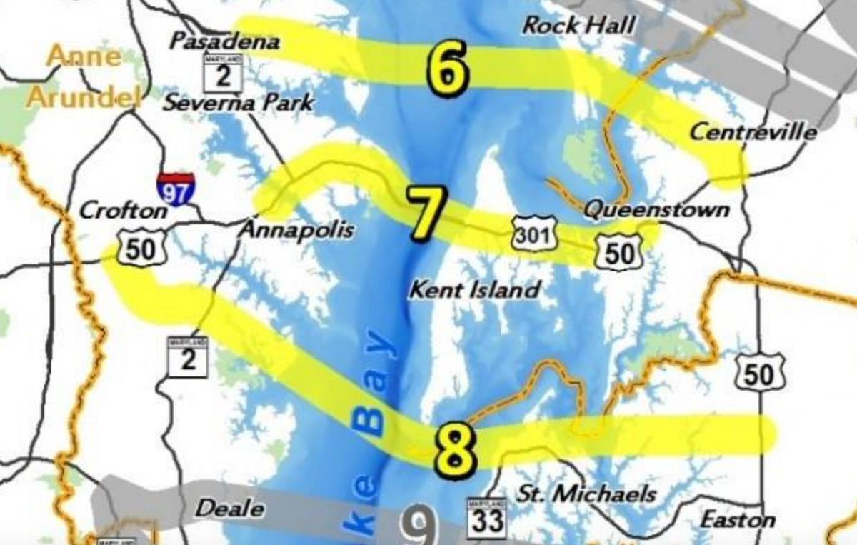
The best location for a third Bay Bridge would be adjacent to the current spans, according to a state agency report. Two other options — one north of the existing bridges and one south — out of the five remaining alternatives also will undergo additional study.
The Maryland Transportation Authority selected the three alternatives based on traffic congestion, safety, dependable and reliable travel times, flexibility for maintenance and incident management, and financial viability.
The ongoing study also will include a no-build alternative.
Phase 1 of the Chesapeake Bay Crossing Study outlined 14 possible alternatives. Corridors 1-4 and 10-14 were eliminated from further consideration because those locations would not provide adequate traffic capacity to reduce congestion at the current crossing.

A study of potential sites for a new crossing of the Chesapeake Bay initially included 14 options. Corridors 6-8, highlighted in yellow, remain under consideration.
Phase 2 looked in more detail at corridors 5-9 and further reduced the alternatives to Corridors 6, 7, and 8.
Corridor 7 is where the existing Bay Bridge spans are located.
Corridor 6 would be north of the current bridges, with the western end located east of Pasadena in Anne Arundel County and the eastern side connecting near Rock Hall in Kent County before crossing the Chester River into Queen Anne’s County and connecting with Route 213 south of Centreville.
Corridor 8 would be south of the current bridges, with the western end located south of Annapolis. The bridge would pass south of Kent Island, connecting with Talbot County and ultimately to U.S. Route 50 north of Easton.
The detailed traffic analysis for the five remaining corridors showed “Corridor 5 would not provide an acceptable level of flexibility for incident diversion and would cause potentially major indirect effects on the Eastern Shore. Corridor 9 would also require substantial additional travel time for incident diversion and would result in unreasonably long duration of queues on summer weekends at the existing crossing (six hours with queues of one mile or greater on non-summer weekdays),” according to the report. And both Corridors 5 and 9 would do little to improve congestion at the current crossing based on traffic projections for 2040.
Cost and environmental impacts also are factors and Corridor 7, with the shortest overall crossing, would likely cost the least and “would likely result in fewer overall direct impacts.”
“While Corridors 6, 7, and 8 are all recommended to be carried forward for further evaluation, the screening results show that Corridor 7 has advantages over Corridors 6 and 8,” according to the report. “The advantages of Corridor 7 include better congestion relief at the existing Bay Bridge, more effective reduction of duration of unacceptable LOS (level of service), more effective backup reduction at the Bay Bridge, the best diversion route, and better compatibility with existing land-use patterns likely resulting in fewer indirect effects.”
Read the full report here:
BCS Alternatives Report


Gren Whitman says
Alternative #6 appears to cross right through the middle of Eastern Neck National Wildlife Refuge and thus would also require a second span across the lower Chester River.
No, thanks!
Alice Marie Barron says
When we first moved to the Chestertown area, we saw a banner proudly displaying the excellence in student academics. We were pleased. Then a need arose for us to have a medical problem and our Hospital was able to accommodate because it had the necessary lab to take care of our problem. WE were pleased. Then little by little the school began to falter and then the
Cath Lab was discontinued. The Birthing center was gone. Housing starts fell. Then some stores closed . We became displeased. To solve these problems.. We need people. Those people would need housing and they would then send their children to school and further become involved in the community. The need for a more advanced Hospital would be a major need. My solution is: BRING on the BRIDGE !!
Gren Whitman says
You would have Kent County turn into just another crowded, traffic-filled Baltimore suburb?
Think twice, because once it’s gone, it’s gone forever.