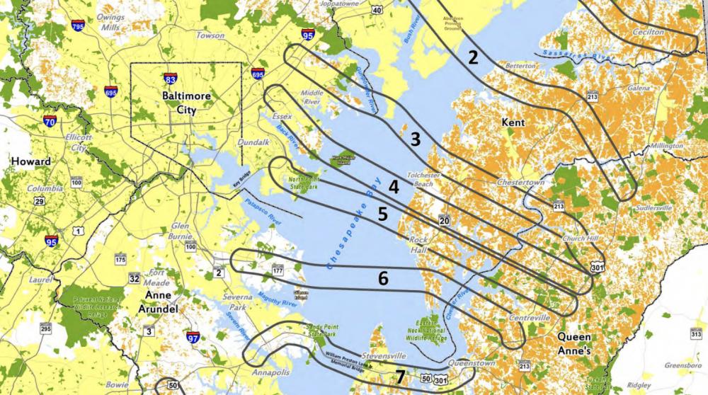


About a year from now, the Maryland Transportation Authority (MdTA) will announce the location of the third Chesapeake Bay Bridge crossing, having chosen from 14 options in Cecil, Kent, Queen Anne’s, Talbot and Dorchester and Somerset counties. A no-build option also is on the table, so I understand.

Maryland Transportation Authority
The impact of a third span on the Eastern Shore will be monumental. Residential and commercial development will follow. Environmental effects will be severe. Quality of life, though an overused term, will take an irreversible blow.
Actual construction would be years off following completion of a federally mandated Environmental Impact Statement. I question how the State of Maryland would finance a $10-20 billion project at a time when public works projects of this size would require a large infusion of private money. Public-private (P3) projects are increasingly more common in the United States,
Nonetheless, the Eastern Shore should gird itself for battle. I say this, knowing that state law grants the Shore veto power over the selection of a crossing. However, state law can be changed, as an Anne Arundel state senator tried and failed to do last year.
As I’ve stated repeatedly in this column, legislative power is in the hands of Western Shore politicians. In this case, they are listening to constituents understandably upset over long waits from traffic congestion heading east and west over the current two Bay Bridge spans during the May-through-September vacation season.
As Eastern Shore residents, environmental groups and politicians prepare their arguments against a project that would undoubtedly change the rural face of Shore, I suggest that a particularly strong one is the real and overwhelming need to protect and preserve product farmland. I’m not minimizing other excellent reasons for opposition, such as environmental degradation and increased real estate development. I’m just tacking one way for this column.
As John Piotti, president and CEO if American Farmland Trust, wrote recently in the Bay Journal, “Farmland is critical infrastructure akin to roads and bridges. It is the source of the food that sustains us. In addition, farmland provides open space, areas for recreation and habitat for wildlife. It also controls floods, suppresses fires, filters water and represents a vast carbon sink to mitigate and even help reverse climate change.
“Think Maryland’s Eastern Shore.”
According to Piotti, Shore farmland contributes more than $8.25 billion to the U.S. economy. Queen Anne’s County contains the most agricultural acreage and the largest farmland economy in Maryland. The largest percentage of land devoted to farming is in Kent County with a figure of 76 percent. The figure is 55 percent in Queen Anne’s County.
According to an academic study conducted in 2013 by professors at Georgia State and Marquette universities, interstate highways cause the conversion of 468 acres for each mile of roadway. I’m guessing it’s a little less for intrastate highways.
No bridge stands alone. It must be accompanied by an extensive road structure leading to and from the high-flying structure. That’s the crux of the problem, apart from the thousands and thousands of cars dumped on the Shore as they hurry to coastal resorts.
There’s no telling if a persuasive argument such as the protection of productive farmland will win the day in the corridors of power in Annapolis. But increased and urgent preservation of farmland in the Delmarva peninsula just might thwart a land grab.
As a member of the board of the Eastern Shore Land Conservancy (ESLC), I well know of this organization’s success in preserving 60,000 acres in 29 years in an area ranging from Cecil to Dorchester County. State, local and land trust preservation programs are vital to keeping vibrant the agricultural economy on the Eastern Shore.
So, what am I proposing?
If a third Bay Bridge span is imminent—as measured possibly by a decade—then I suggest that a new initiative called Delmarva Oasis become part of our area’s consciousness. The intent is to preserve up to 50 percent of the land in Maryland’s Eastern Shore; currently the percentage is roughly 38 percent.
Delmarva Oasis makes particular sense in light of the threat presented by the potential construction of a third Chesapeake Bay Bridge span. It offers a way to protect and preserve valuable, food-producing farmland through the purchase of easements and the direct acquisition of land.
As John Piotti concluded, succinctly and sensibly, “We need to save the land that sustains us. No farms, no food, no future.”
Columnist Howard Freedlander retired in 2011 as Deputy State Treasurer of the State of Maryland. Previously, he was the executive officer of the Maryland National Guard. He also served as community editor for Chesapeake Publishing, lastly at the Queen Anne’s Record-Observer. In retirement, Howard serves on the boards of several non-profits on the Eastern Shore, Annapolis and Philadelphia.
Addendum: A fair number of Spy readers have asked to view the original pdf file of maps associated with Howard Freedlander’s most recent column in the Chestertown Spy and Talbot Spy on the fourteen possible third bay bridge span options produced by Federal Highway Administration and Maryland Transportation Authority. Please review the document here. It is important to note that these maps are clearly labeled, as, “pre-decisional and deliberative.” The Spy appreciates the thoughtful comments on Howard’s piece about the impact of a possible new third span.
Pete Buxtun says
The image that accompanies this article came from where?
Editor says
Maryland Transportation Authority
Elizabeth says
Can we get a link? Google search and concerted “looking” gets me nowhere.
Beryl Smith says
By clicking on the map it can be expanded to make it more readable. It is true there is no text to explain the various options, but seeing it in blowup makes it more understandable.
Elizabeth Watson says
That is certainly a good trick, thanks. But the more important thing is that those of us working to understand the environmental review process for the Bay Crossing study have not seen such a map, and the text that would accompany it on the original website could be quite valuable to our work.
Janet Christensen-Lewis says
Could you please provide the link to this map?
Thank you
Rob Etgen says
Thank you so much for the insightful column about the possibility of a new Chesapeake Bay Bridge crossing. A new Bay Bridge is indeed a sobering concept for our farms, forests, and way of life here on the Eastern Shore.
Given the time lag and cost for any bridge or infrastructure improvements, at Eastern Shore Land Conservancy (ESLC) we think it is critical to explore today how we can minimize Bay Bridge congestion and keep our drivers safe. On April 18 at the Chesapeake Bay Beach Club in Stevensville ESLC will host our 19th Annual Planning Conference focused this year on Bay Bridge traffic. Called “Congestion Ahead: Rerouting…” the conference will showcase things we can do today to minimize congestion while also exploring long term infrastructure solutions. See https://www.eslc.org/events/ for details and to sign up.
Thanks again to Howard and the Spy for stimulating readers to think hard about out of the box solutions for this wonderful region.
Capt. John Steimer says
I can see no need for an additional bridge across the Chesapeake when the existing spans are so underutilized.
There is a simple way to spread the traffic load over a complete 24-hour day. It’s called Surge Pricing.
We know how many vehicles cross the bridges for each hour of the day, and each day of the year. If we vary the toll depending on the time and day we can encourage drivers to change their travel times.
A very simple example would look like the following:
Friday 4 – 7 PM Toll: Double existing toll.
Friday 7 – 11 PM Toll: Same as existing toll
Friday 11 PM – Sat 4 AM Toll $0.00
This is a proven method to encourage drivers to spread the traffic load over a full 24 hours. I would bet you using Surge Pricing would allow for twice the traffic load we now have spread over a full 24-hours.
The people of Maryland do NOT need to spend enormous amounts of money that we do not have, on something we clearly do NOT need.
Keith Thompson says
The opening of the new Rt. 301 in Delaware should greatly increase the need for a new span since the project now creates a high speed route directly connecting Philadelphia to Washington DC (think of it as being an alternate 1-95 bypassing Baltimore). Because of that, I think building a new span at the current bay bridge location is the most likely choice. I think the bigger concern is that there will now be a need to upgrade Rt. 301 on the Eastern Shore. There should also be an ability to make Rt. 301 an economic corridor which, depending on your perspective, should lead to opportunities or challenges for the community.
Deirdre LaMotte says
I agree. I believe this was never about beach traffic
but another route north.
Keith Thompson says
The question I have is why was Rt. 301 built on the Eastern Shore all those years ago? Why have a highway that links Queenstown to the state line near Middletown? The only reason I can think is that it ties in with a regional plan to eventually link with the now open Rt. 301 in Delaware and that highway (and the controversial $4 toll) likely wouldn’t have been built if not for Rt. 301 in Maryland.
Joe Lill says
This is an interesting idea and one that can be implemented almost immediately. It would be a very good case study of how receptive travelers would be to change their driving habits.
Elizabeth Watson says
Mr. Freedlander makes critical points, and the Delmarva Oasis is a highly positive vision to put forward as an alternative to yet more roadways crowding the Eastern Shore. Chesapeake Bay and Maryland’s quality of life as a whole stand to gain much from the Oasis initiative. But everyone should understand that while a goodly share of that already-protected land on Maryland’s Eastern Shore cited by Mr. Freedlander is state or federal natural-resource land–and thus unlikely to be converted wholesale to transportation use (especially the federal)– easements protecting land, such as those held by the Eastern Shore Land Conservancy with much support from private landowners and even state funding, are fair game for use in creating a new bay crossing and all those roads that would go with it. Take Kent County, for example. Not quite 38% is permanently protected, but only Eastern Neck National Wildlife Refuge should not be in play (despite the illustration shown with the story). All the rest of the protected lands here with the probable exception of Sassafras Wildlife Management Area (Maryland’s) are fair game for condemnation and extinguishment of the easements under the public power of eminent domain possessed by the Maryland Transportation Authority. This includes everything from the 3,000-acre easement protecting the Double Woods on Route 20 and all the surrounding natural habitat and agricultural lands managed by Chesapeake Farms, or the much smaller acreage, 268+, under the Maryland Historical Trust easement protecting Fairlee Manor Camp. Not to mention the many farms protected through the Maryland Agricultural Land Preservation Fund (MALPF) that are critical to maintaining valuable food production and the region’s agricultural economy required to produce that food. We have a great deal at risk like this all over the Eastern Shore.
John Leek says
There will come time(s) in the future when climate change, droughts, the gradual depletion of aquifers, and the rise in fossil fuel transportation costs will indeed, imperil our food supply. I think of our local farmlands as the bread basket and safety net for the mid-Atlantic populace, particularly concentrated in urban areas within an hour or so drive. Once farm land is gone, it is gone forever. Like the board game Monopoly, there is only so much farmland property. While this is not anti-development per sea, it is more than reasonable and wise to think about how current decisions will impact the future, similar to the Iroquois considering how their actions would have consequences seven generations afterwards.
Joyce Kim says
Many of my friends and neighbors agree with me that the bridge would change Kent County forever and most say they don’t want the bridge here. However they also say, “They’re going to do what they’re going to do and there is nothing we can do about it.” Is this true? Are we going to let Kent County become a bedroom community for Baltimore? As Mr. Freedlander says, we need to protect the precious farmland in this county and on the Shore and a quality of life that would disappear with a bridge here. For more information we can check the Bay Crossing Study at baycrossingstudy.com and then let the Maryland Transportation Authority planners know what we think about a bay bridge to Kent County.
Patrick Bushby says
I have proposed this ‘paradigm shift’ option for twenty five years: The greater push to cross the Bay are the daily commuters and the ‘reach the beach’ vacationers. Almost all traveling on the Route 50 corridor. Of course the explosion of growth from Kent Island to Salisbury , and all of the towns and cities strung out 50 all the way to Ocean City have exponentially mutliplied the problem. But therein lies the solution:
High speed, light electric rail. An elevated commuter rail line that runs east to west mornings; west to east evenings . Ocean City to Washington, DC. An express train followed by a local that makes quick stops at the cities along the line.
Crossing BETWEEN the twin bridge spans across the Bay ( cross bracing between the two spans to create the “ third bridge” rail bed.) The track runs elevated down Route 50 on reinforced concrete pylon T’s that raiseand lower accordingly.
The ‘horizontal integration’ of the plan lies in its use of paralleling above an existing six lane highway thereby preventing any further despoiling of any other greenways, tiring into existing electric transit grid, while offering a high speed, no stop, no congestion , low fare, stress free commute to and from the population centers that are affected in the first place. Uber, smart cars, city bike – etc pick up at rails end, at a cost that will most likely be less than metered or parking lot rates.
The shift from frustrated driver to a relaxed and stree free rider would be as immediate and dramatic as the day the Chesapeake Bay Bridge opened.
Welcome to the 21st Century. The rest of the developed world is already there.
[email protected] says
I am concerned but not too concerned because ten years or so they did a study a bridge across the Chester River. I went to several meetings where they presented a half a dozen locations and finally decided on the one that comes across at the brick yard. ( That is the same location they decided on ten or twelve years before the latest study, the only one that made made sense. ) SHA had lots of grafts and charts, a whole dog and pony show. They went away and we haven’t heard anything more about the bridge. I am not sure all this studying is not job security for a section of the Highway Administration. That being said, we still have to let them know the bridge to Kent should never happen.
Mike Waal says
Well, I’m sorta late coming to this party;
There are no dates on these maps, so no one knows how old they are, but they do pattern themselves with the six zones originally provided by, and discussed by, the MDTA when the Tier 1 NEPA process started more than two years ago.
Proposed routes one, two and three will never see the light of day, as the infrastructure for a Bridge here would, for the most part, cross thru Aberdeen Proving Grounds. That’s not going to happen. The MDTA knows this, too.
Proposed route 14 will never happen for two reasons: it is too long, and therefore financially not viable, and it will do nothing to address the “Purpose And Need” for another Bay Bridge as defined by the MDTA; it is too far south. The MDTA knows this, too.
Routes four thru six don’t make any sense, from crime-plagued Baltimore to Kent County, as a Bridge at any of these points would dump even more traffic onto an already stressed and congested Route 50, from the Rte 50/301 split down to the DE and MD shore destination points during peak seasonal travel. At 1,500 vehicles per hour per lane during peak seasonal travel times, a new Bridge at any of these points exacerbates the Route 50 congestion, adding 3,000 or 4,500 vehicles per hour, depending on the number of lanes the new Bridge has. And there is no plan, at all, for a Route 50 By-Pass from the split to Cambridge. Albeit, there is a plan to widen the existing roadway by one lane from the split to, maybe, the Easton airport.
Proposed routes eight, nine and 10 would, again, dump 3,000 or 4,500 vehicles per hour onto Rte 50 mid-way between the split and Cambridge. Albeit, some Rte 50 traffic does make that left turn at Route 404 to get to DE shore destination points. I don’t think you’ll see a new Bridge going over or thru St. Michael’s. Do you?!
The proposed routes that make the most sense are either 11 or 12, by diverting Washington, DC and Northern VA ocean shore point destination travelers away from the current Bay Bridges, by coming into Route 50 below Cambridge. According to State Highway Admn, this is when Route 50 traffic starts to thin out, as it gets closer to the Salisbury By-Pass. MDTA criteria for proposed route choosing is also about West Bound Sunday Peak Seasonal Traffic, the heading-home traffic. Choosing either proposed routes 11 or 12 diverts the Washington, DC and Northern VA travelers off Rte 50 well before the current Bridges. And any new Bridge north of the current Bridges would not help alleviate that lower Rte 50 traffic congestion.
Another reason for proposed routes 11 or 12 making more sense than anywhere else would be for the very likelihood of an Emergency Evacuation of the Delmarva due to a life-threatening-storm that would require such an evacuation. It is not an ‘if’ issue, but a ‘when’ issue. All the blue and white Emergency Evacuation Signs all lead to the existing Bay Bridges. A Bridge further north, above the existing Bridges, would not help the evacuation process. Diverting west bound Washington, DC and Northern VA evacuees off the Delmarva as soon as possible, in such an emergency situation, is the best possible solution and logical approach for a life-threatening emergency evacuation situation.
As for additional vehicle lanes [double decking] onto the existing Bridges, the current structure cannot support that architecture. And that just adds additional vehicle count to Route 50 as discussed above. Neither can mass-transit rail be added to the current structure, ditto the current structure cannot support that architecture.
Electronic Toll Lanes will be coming soon to the current Bridge. That will help. However, thoughtful consideration is ongoing because of the contra-flow traffic patterns that prevail. That written, as for adjusting toll rates to help manage peak travel times; that has been studied extensively, with the result being it would not deter seasonal travelers.
As for the Middletown, DE By-Pass effect, that is a wait and see situation, in my opinion. Twenty years ago, when the subject of an additional Bay Bridge became hot and heavy, brought up by then Senator E.J. Pipkin, Middletown By-Pass was NOT part of the conversation. It was all about moving more vehicles across the Bay during peak travel times. All of the previous studies support that proposition. The relevancy of the Middletown By-Pass with its tolls remains a question, which we must diligently take into to account and not overlook.