


The area in red where the November 30, 2017, earthquake was felt.
Did you feel anything odd just before 5:00 pm yesterday, Thursday, Nov. 30? Some shaking? A bump or jolt while driving? Did anything fall or break in your house? If so, you might have experienced the 4.1 magnitude earthquake that struck yesterday at 4:47 pm off the Delaware coast about 6 miles northeast of Dover, Delaware.
A 4.1 earthquake is considered strong enough to cause moderate to considerable damage. The Maryland Emergency Management Agency (MEMA) is trying to determine the extent and severity of the quake. If you felt the quake, MEMA would like to hear from you. The full message from MEMA–with a link to report where you were and what you felt–is at the end of this article on the Dover earthquake, along with a copy of the earthquake survey questions. MEMA needs help from residents to make a “shaking intensity map” of the affected areas.
Earthquakes are rare in the Mid-Atlantic area. In fact, according to the US Geological Survey (USGS), earthquakes are rare east of the Rockies Mountains. The last tremor felt in Delaware was in 2011–that from the 5.8 earthquake centered in Virginia that was felt all up and down the East Coast and, in DC, caused cracks in both the Washington Monument and the National Cathedral. Thursday’s quake was felt as far inland as the I-95 corridor in Maryland, Delaware, and southeastern Pennsylvania as well as in New Jersey and New York to the north. It was felt over 90 miles away in Washington, DC, in Baltimore, in Philadelphia, and 125 miles north in New York City. However, many in these areas said they didn’t notice anything. The USGS said that light shaking was felt as far south as Virginia and as far north as Poughkeepsie, New York and Connecticut. The quake registered at a depth of five miles, which is considered a shallow quake and that shallowness causes the quake to be amplified and felt over a larger area. Earth tremors on the East Coast tend to cause shaking in a wider area than those in western states due to the type of quake, the depth of the quake, and to the type of bedrock.
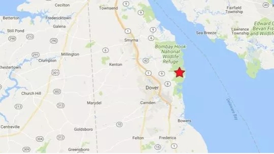
Partial map of Eastern Shore of Maryland showing epicenter –starred– of the Thursday, Nov. 30, 4.1 magnitude earthquake. The quake’s epicenter at the wildlife refuge is roughly 36 miles from Chestertown.
Closer to the quake’s center in Dover, houses shook, windows and loose items rattled, and many people reported a boom and a sound like a train that was loud but only lasted a second or two. In Dover, the ground shook for 10-20 seconds, sending people pouring out of buildings and into the streets where others were already gathering for the Dover Capitol Holiday Celebration and Tree Lighting ceremony. The celebration, which was scheduled for 5 -8:00 pm., continued despite the disruption of the earthquake.
The quake was originally reported at a magnitude of 5.1 then shortly afterward downgraded to 4.4. After examining readings from multiple monitoring stations, the tremor was downgraded to a probably final magnitude of 4.1.
No aftershocks have been reported so far.
The Delaware Emergency Management Agency believes the epicenter was in Bombay Hook National Wildlife Refuge. No injuries, major damage, or interruption of services were reported in the first few hours after the quake. The wildlife refuge is roughly 36 miles from Chestertown.
The Delaware earthquake was one of five earthquakes registered on Thursday in the US’s lower 48 states. But it was the strongest. It was not just the strongest quake on Thursday, Nov. 30, but also the strongest in the US for the month of November. Just 30 minutes after the 4.1 quake in Delaware, there was a tremor–magnitude 3.6–near Salida, Colorado.
Here are the questions on the earthquake survey form from MEMA. To record your experience click on the “jump” link below then click on the 3rd box in the first row with the title “Felt Report–Tell Us!”
Magnitude 4.1 Earthquake – 10km ENE of Dover, Delaware
Felt Report – Tell Us! Expires 05/31/2018
Your location when the earthquake occurred
Choose Location
Did you feel it?
Yes
No
The remainder of this form is optional.
Help make a shaking intensity map by telling us about the shaking at your location.
What was your situation during the earthquake?
Not specified
Inside a building
Outside a building
In a stopped vehicle
In a moving vehicle
Other
Were you asleep?
Not specified
No
Slept through it
Woke up
Did others nearby feel it?
Not specified
No others felt it
Some felt it, most did not
Most felt it
Everyone/almost everyone felt it
How would you describe the shaking?
Not specified
Not felt
Weak
Mild
Moderate
Strong
Violent
How did you react?
Not specified
No reaction/not felt
Very little reaction
Excitement
Somewhat frightened
Very frightened
Extremely frightened
How did you respond?
Not specified
Took no action
Moved to doorway
Dropped and covered
Ran outside
Other
Was it difficult to stand and/or walk?
Not specified
No
Yes
Did you notice any swinging of doors or other free-hanging objects?
Not specified
No
Yes, slight swinging
Yes, violent swinging
Did you hear creaking or other noises?
Not specified
Yes, slight noise
Yes, loud noise
Did objects rattle, topple over, or fall off shelves?
Not specified
No
Rattled slightly
Rattled loudly
A few toppled or fell off
Many fell off
Nearly everything fell off
Did pictures on walls move or get knocked askew?
Not specified
No
Yes, but did not fall
Yes, and some fell
Did any furniture or appliances slide, topple over, or become displaced?
Not specified
No
Yes
Was a heavy appliance (refrigerator or range) affected?
Not specified
No
Yes, some contents fell out
Yes, shifted by inches
Yes, shifted by a foot or more
Yes, overturned
Were free-standing walls or fences damaged?
Not specified
No
Yes, some were cracked
Yes, some partially fell
Yes, some fell completely
Was there any damage to the building?
No Damage
Hairline cracks in walls
A few large cracks in walls
Many large cracks in walls
Ceiling tiles or lighting fixtures fell
Cracks in chimney
One or several cracked windows
Many windows cracked or some broken out
Masonry fell from block or brick wall(s)
Old chimney, major damage or fell down
Modern chimney, major damage or fell down
Outside wall(s) tilted over or collapsed completely
Separation of porch, balcony, or other addition from building
Building permanently shifted over foundation
Additional Comments
Contact Information (optional)
Name
Phone
Submit Cancel
New Jersey is also surveying their residents to discover the range of Thursday’s quake. Their site has an interactive map and totals per town of those who felt the quake.
Official Message from Maryland Emergency Management Agency Monitoring After Earthquake Near Delaware Coast
REISTERSTOWN, Md. (November 30, 2017) — In the wake of the earthquake that hit off the coast of Delaware this afternoon, the Maryland Emergency Management Agency is monitoring for any reports of damage.
The quake, which the United States Geological Survey currently lists as a 4.1 magnitude, hit just before 4:50 p.m. off the Delaware coast, about 6 miles east/northeast of Dover. Reports say it was felt as far east as the I-95 corridor in central Maryland.
The United States Geological Survey asks anyone who may have felt the quake to report it on their website.
While earthquakes are not common in this region, they do happen. In August of 2011, most of Maryland felt a magnitude 5.8 earthquake that was centered near Mineral, Va.
For more information about earthquakes in Maryland, please visit the MEMA website.
For more general information about earthquake preparedness, visit the federal government’s earthquake website.
End Official Mema press release
###
Write a Letter to the Editor on this Article
We encourage readers to offer their point of view on this article by submitting the following form. Editing is sometimes necessary and is done at the discretion of the editorial staff.